 Dunedin South as Next Fox River Dump Disaster?
Written By:
- Date published:
8:00 am, August 10th, 2019 - 75 comments
Categories: climate change, local government, sustainability -
Tags: south dunedin
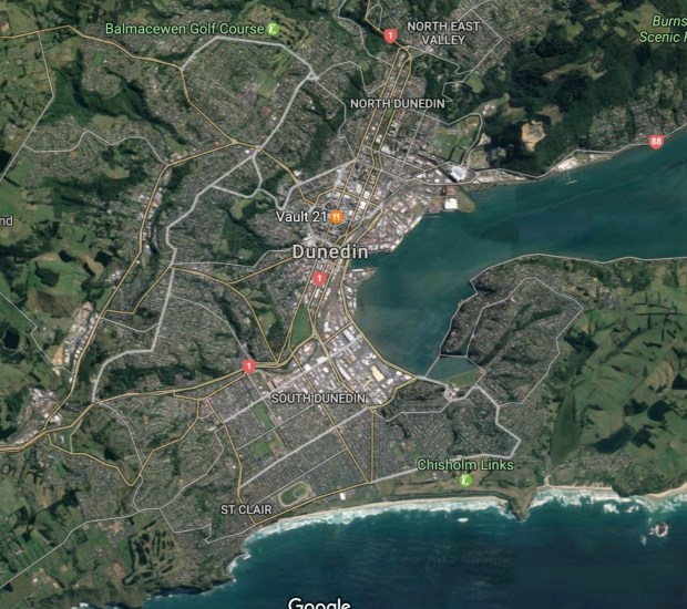
If we thought the devastation and mess caused by a flood ripping through the old dump at Fox Glacier village was bad, just wait until a decent storm punches through the old dump of New Zealand’s fifth largest city on its coastline. It’s getting close.
Dunedin is now preparing to have the massive Kettle Park dump exposed to the sea.
It was previously a sand dune system, and has encroached into the sea over the last century.
But it looks like the sea wants it back.
It’s not like they weren’t warned. In 2015 the whole of South Dunedin underwent massive flooding, not assisted by poorly maintained DCC stormwater drains. I am aware of people whose houses were devastated by that storm that are still gradually recovering.
South Dunedin is also on average home to some of the poorest and most deprived people in New Zealand.
It’s not the paradise first advertised.
I no longer care whether it’s called climate change or the weather. I’m sure there are differences of timescale.
As The Otago Daily Times noted in 2017, most of South Dunedin is under threat from sea level rise, and some of it is under sea water table already.
If this rubbish dump gets exposed, the next thing to go will be the entire racecourse.
After which it’s harder to stop a whole bunch of houses with people in them getting less viable.
Cities that prepare for managed retreat with big plans that help their citizens move will have a better chance than most.
Here comes the next warning.
75 comments on “Dunedin South as Next Fox River Dump Disaster? ”
- Comments are now closed
- Comments are now closed
Recent Comments
- Maori Party (with “disgust”) draws attention to Chhour’s race after the High Court rules on Wa...
 Buzz from the Beehive A statement from Children’s Minister Karen Chhour – yet to be posted on the Government’s official website – arrived in Point of Order’s email in-tray last night. It welcomes the High Court ruling on whether the Waitangi Tribunal can demand she appear before it. It does ...4 hours ago
 - Who’s Going Up The Media Mountain?
 Mr Bombastic: Ironically, the media the academic experts wanted is, in many ways, the media they got. In place of the tyrannical editors of yesteryear, advancing without fear or favour the interests of the ruling class; the New Zealand news media of today boasts a troop of enlightened journalists dedicated to ...6 hours ago
 - “That's how I roll”
 It's hard times try to make a livingYou wake up every morning in the unforgivingOut there somewhere in the cityThere's people living lives without mercy or pityI feel good, yeah I'm feeling fineI feel better then I have for the longest timeI think these pills have been good for meI ...10 hours ago
 - “Comity” versus the rule of law
 In 1974, the US Supreme Court issued its decision in United States v. Nixon, finding that the President was not a King, but was subject to the law and was required to turn over the evidence of his wrongdoing to the courts. It was a landmark decision for the rule ...18 hours ago
 - Aotearoa: a live lab for failed Right-wing socio-economic zombie experiments once more…
 Every day now just seems to bring in more fresh meat for the grinder. In their relentlessly ideological drive to cut back on the “excessive bloat” (as they see it) of the previous Labour-led government, on the mountains of evidence accumulated in such a short period of time do not ...21 hours ago
 - Water is at the heart of farmers’ struggle to survive in Benin
 This is a re-post from Yale Climate Connections by Megan Valére Sosou Market gardening site of the Itchèléré de Itagui agricultural cooperative in Dassa-Zoumè (Image credit: Megan Valère Sossou) For the residents of Dassa-Zoumè, a city in the West African country of Benin, choosing between drinking water and having enough ...1 day ago
 - At a time of media turmoil, Melissa had nothing to proclaim as Minister – and now she has been dem...Buzz from the Beehive
 Melissa Lee – as may be discerned from the screenshot above – has not been demoted for doing something seriously wrong as Minister of ... 1 day ago
 - These people are not our friends
 Morning in London Mother hugs beloved daughter outside the converted shoe factory in which she is living.Afternoon in London Travelling writer takes himself and his wrist down to A&E, just to be sure. Read more ...1 day ago
 - Some advice from our tertiary history for the University Advisory Group
 Mike Grimshaw writes – The recent announcement of the University Advisory Group, chaired by Sir Peter Gluckman, makes very clear where the Government’s focus and priorities lie. The remit of the Advisory Group is that Group members will consider challenges and opportunities for improvement in the university sector including: ...1 day ago
 - Still no prudential regulation case around climate changeEric Crampton writes – The Reserve Bank of New Zealand desperately wants to find reasons to have workstreams in climate change. It makes little sense. They’ve run another stress test on the banks looking to see if they could find a prudential regulation case. They couldn’t. They ...1 day ago
- Bernard’s pick ‘n’ mix of the news links for Wednesday, April 24
 TL;DR: These six news links stood out to me in the last 24 hours or so onWednesday, April 23:Scoop: 'Released in error': Treasury paper hints at axing $6b flood resilience plan by NZ Herald-$$$ Thomas CoughlanScoop: EY launches new misconduct review amid Fonterra ban. Fonterra tells EY to remove some ...1 day ago
 - How National can neutralise serious allegations of corruption should the “Fast Track” Bill becom...Rob MacCullough writes – Pundits from the left and the right are arguing that National’s Fast Track Bill that is designed to speed up infrastructure decisions could end up becoming mired in a cesspool of corruption. Political commentator ...1 day ago
- Cleaning Up After Gabrielle.
 Looking at the headlines this morning it’s hard to feel anything other than pessimistic about the future of humanity.Note that I’m not speaking about the future of mankind, but the survival of our humanity. The values that we believe in seem to be ebbing away, by the day.Perhaps every generation ...1 day ago
 - Gordon Campbell on bird flu, AUKUS entry fees and Cindy Lee
 Swabbing mixed breed baby chicks to test for avian influenzaUh oh. Bird flu – often deadly to humans – is not only being transmitted from infected birds to dairy cows, but is now travelling between dairy cows. As of last Friday, Bloomberg News reports, there were 32 American dairy herds ...1 day ago
 - Tolling Existing Roads
 One of the government’s transport policy and agreements with it’s coalition partners made it clear that they were looking at options like tolling and road pricing. This was reinforced in it’s draft Government Policy Statement released at the start of March which made a couple of references to it. Road pricing, ...1 day ago
 - At a glance – The difference between weather and climateOn February 14, 2023 we announced our Rebuttal Update Project. This included an ask for feedback about the added "At a glance" section in the updated basic rebuttal versions. This weekly blog post series highlights this new section of one of the updated basic rebuttal versions and serves as a ...2 days ago
- More criminal minersWhat is it with the mining industry? Its not enough for them to pillage the earth - they apparently can't even be bothered getting resource consent to do so: The proponent behind a major mine near the Clutha River had already been undertaking activity in the area without a ...2 days ago
- Photos from the road
 Photo # 1 I am a huge fan of Singapore’s approach to housing, as described here two years ago by copying and pasting from The ConversationWhat Singapore has that Australia does not is a public housing developer, the Housing Development Board, which puts new dwellings on public and reclaimed land, ...2 days ago
 - RMA reforms aim to ease stock-grazing rules and reduce farmers’ costs – but Taxpayers’ Union w...Buzz from the Beehive Reactions to news of the government’s readiness to make urgent changes to “the resource management system” through a Bill to amend the Resource Management Act (RMA) suggest a balanced approach is being taken. The Taxpayers’ Union says the proposed changes don’t go far enough. Greenpeace says ...2 days ago
- Luxon Strikes Out.
 I’m starting to wonder if Anna Burns-Francis might be the best political interviewer we’ve got. That might sound unlikely to you, it came as a bit of a surprise to me.Jack Tame can be excellent, but has some pretty average days. I like Rebecca Wright on Newshub, she asks good ...2 days ago
 - In many ways the media that the experts wanted, turned out to be the media they have gotChris Trotter writes – Willie Jackson is said to be planning a “media summit” to discuss “the state of the media and how to protect Fourth Estate Journalism”. Not only does the Editor of The Daily Blog, Martyn Bradbury, think this is a good idea, but he has also ...2 days ago
- The Waitangi Tribunal Summons; or the more things stay the sameGraeme Edgeler writes – This morning [April 21], the Wellington High Court is hearing a judicial review brought by Hon. Karen Chhour, the Minister for Children, against a decision of the Waitangi Tribunal. This is unusual, judicial reviews are much more likely to brought against ministers, rather than ...2 days ago
- Both Parliamentary watchdogs hammer Fast-track bill
 Both of Parliament’s watchdogs have now ripped into the Government’s Fast-track Approvals Bill. Photo: Lynn Grieveson / The KākāMy pick of the six newsey things to know from Aotearoa’s political economy and beyond on the morning of Tuesday, April 23 are:The Lead: The Auditor General, John Ryan, has joined the ...2 days ago
 - India makes a big bet on electric busesThis is a re-post from Yale Climate Connections by Sarah Spengeman People wait to board an electric bus in Pune, India. (Image credit: courtesy of ITDP) Public transportation riders in Pune, India, love the city’s new electric buses so much they will actually skip an older diesel bus that ...2 days ago
- Bernard’s pick ‘n’ mix of the news links at 6:36am on Tuesday, April 23
 TL;DR: These six news links stood out in the last 24 hours to 6:36am on Tuesday, April 22:Scoop & Deep Dive: How Sir Peter Jackson got to have his billion-dollar exit cake and eat Hollywood too NZ Herald-$$$ Matt NippertFast Track Approval Bill: Watchdogs seek substantial curbs on ministers' powers ...3 days ago
 - What is really holding up infrastructureThe infrastructure industry yesterday issued a “hurry up” message to the Government, telling it to get cracking on developing a pipeline of infrastructure projects.The hiatus around the change of Government has seen some major projects cancelled and others delayed, and there is uncertainty about what will happen with the new ...3 days ago
- “Pure Unadulterated Charge”
 Hi,Over the weekend I revisited a podcast I really adore, Dead Eyes. It’s about a guy who got fired from Band of Brothers over two decades ago because Tom Hanks said he had “dead eyes”.If you don’t recall — 2001’s Band of Brothers was part of the emerging trend of ...3 days ago
 - Bernard's six-stack of substacks for Monday, April 22
 Tonight’s six-stack includes: writes via his substack that’s he’s sceptical about the IPSOS poll last week suggesting a slide into authoritarianism here, writing: Kiwis seem to want their cake and eat it too Tal Aster writes for about How Israel turned homeowners into YIMBYs. writes via his ...3 days ago
 - The media were given a little list and hastened to pick out Fast Track prospects – but the Treaty ...Buzz from the Beehive The 180 or so recipients of letters from the Government telling them how to submit infrastructure projects for “fast track” consideration includes some whose project applications previously have been rejected by the courts. News media were quick to feature these in their reports after RMA Reform Minister Chris ...3 days ago
- Just trying to stay upright
 It would not be a desirable way to start your holiday by breaking your back, your head, or your wrist, but on our first hour in Singapore I gave it a try.We were chatting, last week, before we started a meeting of Hazel’s Enviro Trust, about the things that can ...3 days ago
 - “Unprecedented”Today, former Port of Auckland CEO Tony Gibson went on trial on health and safety charges for the death of one of his workers. The Herald calls the trial "unprecedented". Firstly, it's only "unprecedented" because WorkSafe struck a corrupt and unlawful deal to drop charges against Peter Whittall over Pike ...3 days ago
- Bryce Edwards: Time for “Fast-Track Watch”
 Calling all journalists, academics, planners, lawyers, political activists, environmentalists, and other members of the public who believe that the relationships between vested interests and politicians need to be scrutinised. We need to work together to make sure that the new Fast-Track Approvals Bill – currently being pushed through by the ...3 days ago
 - Gordon Campbell on fast track powers, media woes and the Tiktok banFeel worried. Shane Jones and a couple of his Cabinet colleagues are about to be granted the power to override any and all objections to projects like dams, mines, roads etc even if: said projects will harm biodiversity, increase global warming and cause other environmental harms, and even if ...3 days ago
- The Government’s new fast-track invitation to corruption
 Bryce Edwards writes- The ability of the private sector to quickly establish major new projects making use of the urban and natural environment is to be supercharged by the new National-led Government. Yesterday it introduced to Parliament one of its most significant reforms, the Fast Track Approvals Bill. ...3 days ago
 - Maori push for parallel government structuresMichael Bassett writes – If you think there is a move afoot by the radical Maori fringe of New Zealand society to create a parallel system of government to the one that we elect at our triennial elections, you aren’t wrong. Over the last few days we have ...3 days ago
- An announcement about an announcementWithout a corresponding drop in interest rates, it’s doubtful any changes to the CCCFA will unleash a massive rush of home buyers. Photo: Lynn GrievesonTL;DR: The six things that stood out to me in Aotearoa’s political economy around housing, poverty and climate on Monday, April 22 included:The Government making a ...3 days ago
- All the Green Tech in China.
 Sunday was a lazy day. I started watching Jack Tame on Q&A, the interviews are usually good for something to write about. Saying the things that the politicians won’t, but are quite possibly thinking. Things that are true and need to be extracted from between the lines.As you might know ...3 days ago
 - Western Express SuccessIn our Weekly Roundup last week we covered news from Auckland Transport that the WX1 Western Express is going to get an upgrade next year with double decker electric buses. As part of the announcement, AT also said “Since we introduced the WX1 Western Express last November we have seen ...3 days ago
- Bernard’s pick ‘n’ mix of the news links at 7:16am on Monday, April 22
 TL;DR: These six news links stood out in the last 24 hours to 7:16am on Monday, April 22:Labour says Kiwis at greater risk from loan sharks as Govt plans to remove borrowing regulations NZ Herald Jenee TibshraenyHow did the cost of moving two schools blow out to more than $400m?A ...3 days ago
 - The Kaka’s diary for the week to April 29 and beyond
 TL;DR: The six key events to watch in Aotearoa-NZ’s political economy in the week to April 29 include:PM Christopher Luxon is scheduled to hold a post-Cabinet news conference at 4 pm today. Stats NZ releases its statutory report on Census 2023 tomorrow.Finance Minister Nicola Willis delivers a pre-Budget speech at ...4 days ago
 - 2024 SkS Weekly Climate Change & Global Warming News Roundup #16A listing of 29 news and opinion articles we found interesting and shared on social media during the past week: Sun, April 14, 2024 thru Sat, April 20, 2024. Story of the week Our story of the week hinges on these words from the abstract of a fresh academic ...4 days ago
- Bryce Edwards: The Government’s new fast-track invitation to corruptionThe ability of the private sector to quickly establish major new projects making use of the urban and natural environment is to be supercharged by the new National-led Government. Yesterday it introduced to Parliament one of its most significant reforms, the Fast Track Approvals Bill. The Government says this will ...4 days ago
- Thank you
 This is a column to say thank you. So many of have been in touch since Mum died to say so many kind and thoughtful things. You’re wonderful, all of you. You’ve asked how we’re doing, how Dad’s doing. A little more realisation each day, of the irretrievable finality of ...5 days ago
 - Determining the Engine Type in Your Car
 Identifying the engine type in your car is crucial for various reasons, including maintenance, repairs, and performance upgrades. Knowing the specific engine model allows you to access detailed technical information, locate compatible parts, and make informed decisions about modifications. This comprehensive guide will provide you with a step-by-step approach to ...5 days ago
 - How to Become a Race Car Driver: A Comprehensive GuideIntroduction: The allure of racing is undeniable. The thrill of speed, the roar of engines, and the exhilaration of competition all contribute to the allure of this adrenaline-driven sport. For those who yearn to experience the pinnacle of racing, becoming a race car driver is the ultimate dream. However, the ...5 days ago
- How Many Cars Are There in the World in 2023? An Exploration of Global Automotive StatisticsIntroduction Automobiles have become ubiquitous in modern society, serving as a primary mode of transportation and a symbol of economic growth and personal mobility. With countless vehicles traversing roads and highways worldwide, it begs the question: how many cars are there in the world? Determining the precise number is a ...5 days ago
- How Long Does It Take for Car Inspection?Maintaining a safe and reliable vehicle requires regular inspections. Whether it’s a routine maintenance checkup or a safety inspection, knowing how long the process will take can help you plan your day accordingly. This article delves into the factors that influence the duration of a car inspection and provides an ...5 days ago
- Who Makes Mazda Cars?Mazda Motor Corporation, commonly known as Mazda, is a Japanese multinational automaker headquartered in Fuchu, Aki District, Hiroshima Prefecture, Japan. The company was founded in 1920 as the Toyo Cork Kogyo Co., Ltd., and began producing vehicles in 1931. Mazda is primarily known for its production of passenger cars, but ...5 days ago
- How Often to Replace Your Car Battery A Comprehensive GuideYour car battery is an essential component that provides power to start your engine, operate your electrical systems, and store energy. Over time, batteries can weaken and lose their ability to hold a charge, which can lead to starting problems, power failures, and other issues. Replacing your battery before it ...5 days ago
- Can You Register a Car Without a License?In most states, you cannot register a car without a valid driver’s license. However, there are a few exceptions to this rule. Exceptions to the Rule If you are under 18 years old: In some states, you can register a car in your name even if you do not ...5 days ago
- Mazda: A Comprehensive Evaluation of Reliability, Value, and PerformanceMazda, a Japanese automotive manufacturer with a rich history of innovation and engineering excellence, has emerged as a formidable player in the global car market. Known for its reputation of producing high-quality, fuel-efficient, and driver-oriented vehicles, Mazda has consistently garnered praise from industry experts and consumers alike. In this article, ...5 days ago
- What Are Struts on a Car?Struts are an essential part of a car’s suspension system. They are responsible for supporting the weight of the car and damping the oscillations of the springs. Struts are typically made of steel or aluminum and are filled with hydraulic fluid. How Do Struts Work? Struts work by transferring the ...5 days ago
- What Does Car Registration Look Like: A Comprehensive GuideCar registration is a mandatory process that all vehicle owners must complete annually. This process involves registering your car with the Department of Motor Vehicles (DMV) and paying an associated fee. The registration process ensures that your vehicle is properly licensed and insured, and helps law enforcement and other authorities ...5 days ago
- How to Share Computer Audio on ZoomZoom is a video conferencing service that allows you to share your screen, webcam, and audio with other participants. In addition to sharing your own audio, you can also share the audio from your computer with other participants. This can be useful for playing music, sharing presentations with audio, or ...5 days ago
- How Long Does It Take to Build a Computer?Building your own computer can be a rewarding and cost-effective way to get a high-performance machine tailored to your specific needs. However, it also requires careful planning and execution, and one of the most important factors to consider is the time it will take. The exact time it takes to ...5 days ago
- How to Put Your Computer to SleepSleep mode is a power-saving state that allows your computer to quickly resume operation without having to boot up from scratch. This can be useful if you need to step away from your computer for a short period of time but don’t want to shut it down completely. There are ...5 days ago
- What is Computer-Assisted Translation (CAT)?Introduction Computer-Assisted Translation (CAT) has revolutionized the field of translation by harnessing the power of technology to assist human translators in their work. This innovative approach combines specialized software with human expertise to improve the efficiency, accuracy, and consistency of translations. In this comprehensive article, we will delve into the ...5 days ago
- iPad vs. Tablet Computers A Comprehensive Guide to DifferencesIn today’s digital age, mobile devices have become an indispensable part of our daily lives. Among the vast array of portable computing options available, iPads and tablet computers stand out as two prominent contenders. While both offer similar functionalities, there are subtle yet significant differences between these two devices. This ...5 days ago
- How Are Computers Made?A computer is an electronic device that can be programmed to carry out a set of instructions. The basic components of a computer are the processor, memory, storage, input devices, and output devices. The Processor The processor, also known as the central processing unit (CPU), is the brain of the ...5 days ago
- How to Add Voice Memos from iPhone to ComputerVoice Memos is a convenient app on your iPhone that allows you to quickly record and store audio snippets. These recordings can be useful for a variety of purposes, such as taking notes, capturing ideas, or recording interviews. While you can listen to your voice memos on your iPhone, you ...5 days ago
- Why My Laptop Screen Has Lines on It: A Comprehensive GuideLaptop screens are essential for interacting with our devices and accessing information. However, when lines appear on the screen, it can be frustrating and disrupt productivity. Understanding the underlying causes of these lines is crucial for finding effective solutions. Types of Screen Lines Horizontal lines: Also known as scan ...5 days ago
- How to Right-Click on a LaptopRight-clicking is a common and essential computer operation that allows users to access additional options and settings. While most desktop computers have dedicated right-click buttons on their mice, laptops often do not have these buttons due to space limitations. This article will provide a comprehensive guide on how to right-click ...5 days ago
- Where is the Power Button on an ASUS Laptop?Powering up and shutting down your ASUS laptop is an essential task for any laptop user. Locating the power button can sometimes be a hassle, especially if you’re new to ASUS laptops. This article will provide a comprehensive guide on where to find the power button on different ASUS laptop ...5 days ago
- How to Start a Dell Laptop: A Comprehensive GuideDell laptops are renowned for their reliability, performance, and versatility. Whether you’re a student, a professional, or just someone who needs a reliable computing device, a Dell laptop can meet your needs. However, if you’re new to Dell laptops, you may be wondering how to get started. In this comprehensive ...5 days ago
- Bryce Edwards: Serious populist discontent is bubbling up in New ZealandTwo-thirds of the country think that “New Zealand’s economy is rigged to advantage the rich and powerful”. They also believe that “New Zealand needs a strong leader to take the country back from the rich and powerful”. These are just two of a handful of stunning new survey results released ...5 days ago
- How to Take a Screenshot on an Asus Laptop A Comprehensive Guide with Detailed Instructions and Illu...In today’s digital world, screenshots have become an indispensable tool for communication and documentation. Whether you need to capture an important email, preserve a website page, or share an error message, screenshots allow you to quickly and easily preserve digital information. If you’re an Asus laptop user, there are several ...5 days ago
- How to Factory Reset Gateway Laptop A Comprehensive GuideA factory reset restores your Gateway laptop to its original factory settings, erasing all data, apps, and personalizations. This can be necessary to resolve software issues, remove viruses, or prepare your laptop for sale or transfer. Here’s a step-by-step guide on how to factory reset your Gateway laptop: Method 1: ...5 days ago
- The Folly Of Impermanence.“You talking about me?” The neoliberal denigration of the past was nowhere more unrelenting than in its depiction of the public service. The Post Office and the Railways were held up as being both irremediably inefficient and scandalously over-manned. Playwright Roger Hall’s “Glide Time” caricatures were presented as accurate depictions of ...5 days ago
- A crisis of ambitionRoger Partridge writes – When the Coalition Government took office last October, it inherited a country on a precipice. With persistent inflation, decades of insipid productivity growth and crises in healthcare, education, housing and law and order, it is no exaggeration to suggest New Zealand’s first-world status was ...5 days ago
- Have 308 people in the Education Ministry’s Curriculum Development Team spent over $100m on a 60-p...Rob MacCulloch writes – In 2022, the Curriculum Centre at the Ministry of Education employed 308 staff, according to an Official Information Request. Earlier this week it was announced 202 of those staff were being cut. When you look up “The New Zealand Curriculum” on the Ministry of ...5 days ago
- 'This bill is dangerous for the environment and our democracy'Chris Bishop’s bill has stirred up a hornets nest of opposition. Photo: Lynn Grieveson for The KākāTL;DR: The six things that stood out to me in Aotearoa’s political economy around housing, poverty and climate from the last day included:A crescendo of opposition to the Government’s Fast Track Approvals Bill is ...5 days ago
- The Bank of our Tamariki and Mokopuna.
 Monday left me brokenTuesday, I was through with hopingWednesday, my empty arms were openThursday, waiting for love, waiting for loveThe end of another week that left many of us asking WTF? What on earth has NZ gotten itself into and how on earth could people have voluntarily signed up for ...5 days ago
 - The worth of it all
 Hello! Here comes the Saturday edition of More Than A Feilding, catching you up on the past week’s editions.State of humanity, 20242024, it feels, keeps presenting us with ever more challenges, ever more dismay.Do you give up yet? It seems to ask.No? How about this? Or this?How about this?Full story Share ...5 days ago
 - What is the Hardest Sport in the World?Determining the hardest sport in the world is a subjective matter, as the difficulty level can vary depending on individual abilities, physical attributes, and experience. However, based on various factors including physical demands, technical skills, mental fortitude, and overall accomplishment, here is an exploration of some of the most challenging ...6 days ago
- What is the Most Expensive Sport?The allure of sport transcends age, culture, and geographical boundaries. It captivates hearts, ignites passions, and provides unparalleled entertainment. Behind the spectacle, however, lies a fascinating world of financial investment and expenditure. Among the vast array of competitive pursuits, one question looms large: which sport carries the hefty title of ...6 days ago
- Release: Working together on consistent support for veterans this Anzac Day
 Our two-tiered system for veterans’ support is out of step with our closest partners, and all parties in Parliament should work together to fix it, Labour veterans’ affairs spokesperson Greg O’Connor said. ...1 day ago
 - Release: Penny drops – but what about Seymour and Peters?Stripping two Ministers of their portfolios just six months into the job shows Christopher Luxon’s management style is lacking, Labour Leader Chris Hipkins said. ...1 day ago
- Release: Budget blunder shows Nicola Willis could cut recovery fundingIt appears Nicola Willis is about to pull the rug out from under the feet of local communities still dealing with the aftermath of last year’s severe weather, and local councils relying on funding to build back from these disasters. ...2 days ago
- Further environmental mismanagement on the cards
 The Government’s resource management reforms will add to the heavy and ever-growing burden this Government is loading on to our environment. ...2 days ago
 - Release: RMA changes will be a disaster for environmentThe Government is making short-sighted changes to the Resource Management Act (RMA) that will take away environmental protection in favour of short-term profits, Labour’s environment spokesperson Rachel Brooking said today. ...2 days ago
- Release: Labour supports urgent changes to emergency management systemLabour welcomes the release of the report into the North Island weather events and looks forward to working with the Government to ensure that New Zealand is as prepared as it can be for the next natural disaster. ...2 days ago
- Release: Labour calls for New Zealand to recognise PalestineThe Labour Party has called for the New Zealand Government to recognise Palestine, as a material step towards progressing the two-State solution needed to achieve a lasting peace in the region. ...3 days ago
- Release: Three strikes law political posturing of worst kindThe Government is bringing back a law that has little evidential backing just to look tough, Labour justice spokesperson Duncan Webb said. ...3 days ago
- Release: Government cuts unbelievably target child exploitation, violent extremism, ports and airpor...Some of our country’s most important work, stopping the sexual exploitation of children and violent extremism could go along with staff on the frontline at ports and airports. ...3 days ago
- Three strikes has failed before and will fail againResurrecting the archaic three-strikes legislation is an unwelcome return to a failed American-style approach to justice. ...3 days ago
- Release: Environmental protection vital, not ‘onerous’The Government’s Fast Track Approvals Bill will give projects such as new coal mines a ‘get out of jail free’ card to wreak havoc on the environment, Labour Leader Chris Hipkins said today. ...3 days ago
- Release: Govt cuts doctors and nurses in hiring freezeCuts to frontline hospital staff are not only a broken election promise, it shows the reckless tax cuts have well and truly hit the frontline of the health system, says Labour Health spokesperson Ayesha Verrall. ...6 days ago
- Fast-track submissions period must be extendedThe Green Party has joined the call for public submissions on the fast-track legislation to be extended after the Ombudsman forced the Government to release the list of organisations invited to apply just hours before submissions close. ...6 days ago
- Release: Progress on climate will be undone by GovtNew Zealand’s good work at reducing climate emissions for three years in a row will be undone by the National government’s lack of ambition and scrapping programmes that were making a difference, Labour Party climate spokesperson Megan Woods said today. ...6 days ago
- Release: Dark day for Kiwi kids as a third of Govt cuts affect themNews that 1000 jobs at the Ministry of Education and Oranga Tamariki could go is devastating for future generations of New Zealanders. ...1 week ago
- Release: Alarm as Government signals further blow to school lunchesMore essential jobs could be on the chopping block, this time Ministry of Education staff on the school lunches team are set to find out whether they're in line to lose their jobs. ...1 week ago
- Release: Quick, submit – stop Govt’s dodgy approvals billThe Government is trying to bring in a law that will allow Ministers to cut corners and kill off native species, Labour environment spokesperson Rachel Brooking said. ...1 week ago
- Government throws coal on the climate crisis fireThe Government’s policy announced today to ease consenting for coal mining will have a lasting impact across generations. ...1 week ago
- Release: Public transport costs to double as National looks at unaffordable roading project insteadCancelling urgently needed new Cook Strait ferries and hiking the cost of public transport for many Kiwis so that National can announce the prospect of another tunnel for Wellington is not making good choices, Labour Transport Spokesperson Tangi Utikere said. ...1 week ago
- Release: Cost of living in Auckland still not a priorityA laundry list of additional costs for Tāmaki Makarau Auckland shows the Minister for the city is not delivering for the people who live there, says Labour Auckland Issues spokesperson Shanan Halbert. ...1 week ago
- Greens look to fast-track submissions on harmful lawThe Green Party has today launched a step-by-step guide to help New Zealanders make their voice heard on the Government’s democracy dodging and anti-environment fast track legislation. ...2 weeks ago
- Release: Govt should stop making people’s lives harder and build more homesThe National Government’s proposed changes to the Residential Tenancies Act will mean tenants can be turfed from their homes by landlords with little notice, Labour housing spokesperson Kieran McAnulty said. ...2 weeks ago
- Release: Melissa Lee missing in action on mediaThe action Melissa Lee promised to protect democracy and the media sector is missing, Media and Communications spokesperson Willie Jackson said. ...2 weeks ago
- Landlord Government leaves little hope for rentersThe Government’s announcement on tenancy rules prove that it does not care about renters. ...2 weeks ago
- Opportunity to build a more sustainable economyGreen Party co-leader Marama Davidson is calling on all parties to support a common-sense change that’s great for the planet and great for consumers after her member’s bill was drawn from the ballot today. ...2 weeks ago
- Significant step forward in fixing cruel and unjust pastA significant milestone has been reached in the fight to strike an anti-Pasifika and unfair law from the country’s books after Teanau Tuiono’s members’ bill passed its first reading. ...2 weeks ago
- Missed opportunity but NZ will surely one day recognise the right to a sustainable environmentNew Zealand has today missed the opportunity to uphold the right to a clean, healthy, and sustainable environment, says James Shaw after his member’s bill was voted down in its first reading. ...2 weeks ago
- Release: Don’t cut our lunches – clear message sent to GovernmentTens of thousands of people are demanding the Government commits to fully funding free and healthy school lunches. ...2 weeks ago
- Release: Govt makes U-turn on Suicide Prevention OfficeLabour welcomes the Government’s U-turn on the closure of the Suicide Prevention Office, says Labour Mental Health spokesperson Ingrid Leary. ...2 weeks ago
- CCC issues warning over further climate delayToday’s advice from the Climate Change Commission paints a sobering reality of the challenge we face in combating climate change, especially in light of recent Government policy announcements. ...2 weeks ago
- Luxon targets lame and lousy example of leadershipIf talk is cheap, Chris Luxon’s “targets” are bankrupt. ...2 weeks ago
- Luxon targets are lousy example of leadershipIf talk is cheap, Chris Luxon’s “targets” are bankrupt. ...2 weeks ago
- Release: Commitment to disability communities missing from Govt prioritiesMinister for Disability Issues Penny Simmonds appears to have delayed a report back to Cabinet on the progress New Zealand is making against international obligations for disabled New Zealanders. ...2 weeks ago
- Methane target review is dangerous duplicationThe Government’s newly announced review of methane emissions reduction targets hints at its desire to delay Aotearoa New Zealand’s urgent transition to a climate safe future, the Green Party said. ...3 weeks ago
- Anzac Commemorative Address – Dawn Service, Gallipoli, Türkiye
 Mai ia tawhiti pamamao, te moana nui a Kiwa, kua tae whakaiti mai matou, ki to koutou papa whenua. No koutou te tapuwae, no matou te tapuwae, kua honoa pumautia. Ko nga toa kua hinga nei, o te Waipounamu, o te Ika a Maui, he okioki tahi me o ...4 hours ago
 - PM announces changes to portfoliosPaul Goldsmith will take on responsibility for the Media and Communications portfolio, while Louise Upston will pick up the Disability Issues portfolio, Prime Minister Christopher Luxon announced today. “Our Government is relentlessly focused on getting New Zealand back on track. As issues change in prominence, I plan to adjust Ministerial ...1 day ago
- New catch limits for unique fishery areasRecreational catch limits will be reduced in areas of Fiordland and the Chatham Islands to help keep those fisheries healthy and sustainable, Oceans and Fisheries Minister Shane Jones says. The lower recreational daily catch limits for a range of finfish and shellfish species caught in the Fiordland Marine Area and ...1 day ago
- Minister welcomes hydrogen milestoneEnergy Minister Simeon Brown has welcomed an important milestone in New Zealand’s hydrogen future, with the opening of the country’s first network of hydrogen refuelling stations in Wiri. “I want to congratulate the team at Hiringa Energy and its partners K one W one (K1W1), Mitsui & Co New Zealand ...2 days ago
- Urgent changes to system through first RMA Amendment BillThe coalition Government is delivering on its commitment to improve resource management laws and give greater certainty to consent applicants, with a Bill to amend the Resource Management Act (RMA) expected to be introduced to Parliament next month. RMA Reform Minister Chris Bishop has today outlined the first RMA Amendment ...2 days ago
- Overseas decommissioning models consideredOverseas models for regulating the oil and gas sector, including their decommissioning regimes, are being carefully scrutinised as a potential template for New Zealand’s own sector, Resources Minister Shane Jones says. The Coalition Government is focused on rebuilding investor confidence in New Zealand’s energy sector as it looks to strengthen ...2 days ago
- Release of North Island Severe Weather Event InquiryEmergency Management and Recovery Minister Mark Mitchell has today released the Report of the Government Inquiry into the response to the North Island Severe Weather Events. “The report shows that New Zealand’s emergency management system is not fit-for-purpose and there are some significant gaps we need to address,” Mr Mitchell ...2 days ago
- Justice Minister to attend Human Rights CouncilJustice Minister Paul Goldsmith is today travelling to Europe where he’ll update the United Nations Human Rights Council on the Government’s work to restore law and order. “Attending the Universal Periodic Review in Geneva provides us with an opportunity to present New Zealand’s human rights progress, priorities, and challenges, while ...3 days ago
- Patterson reopens world’s largest wool scouring facilityAssociate Agriculture Minister, Mark Patterson, formally reopened the world’s largest wool processing facility today in Awatoto, Napier, following a $50 million rebuild and refurbishment project. “The reopening of this facility will significantly lift the economic opportunities available to New Zealand’s wool sector, which already accounts for 20 per cent of ...3 days ago
- Speech to the Southland Otago Regional Engineering Collective Summit, 18 April 2024Hon Andrew Bayly, Minister for Small Business and Manufacturing At the Southland Otago Regional Engineering Collective (SOREC) Summit, 18 April, Dunedin Ngā mihi nui, Ko Andrew Bayly aho, Ko Whanganui aho Good Afternoon and thank you for inviting me to open your summit today. I am delighted ...3 days ago
- Government to introduce revised Three Strikes lawThe Government is delivering on its commitment to bring back the Three Strikes legislation, Associate Justice Minister Nicole McKee announced today. “Our Government is committed to restoring law and order and enforcing appropriate consequences on criminals. We are making it clear that repeat serious violent or sexual offending is not ...3 days ago
- New diplomatic appointmentsForeign Minister Winston Peters has today announced four new diplomatic appointments for New Zealand’s overseas missions. “Our diplomats have a vital role in maintaining and protecting New Zealand’s interests around the world,” Mr Peters says. “I am pleased to announce the appointment of these senior diplomats from the ...3 days ago
- Humanitarian support for Ethiopia and SomaliaNew Zealand is contributing NZ$7 million to support communities affected by severe food insecurity and other urgent humanitarian needs in Ethiopia and Somalia, Foreign Minister Rt Hon Winston Peters announced today. “Over 21 million people are in need of humanitarian assistance across Ethiopia, with a further 6.9 million people ...3 days ago
- Arts Minister congratulates Mataaho CollectiveMinister for Arts, Culture and Heritage Paul Goldsmith is congratulating Mataaho Collective for winning the Golden Lion for best participant in the main exhibition at the Venice Biennale. "Congratulations to the Mataaho Collective for winning one of the world's most prestigious art prizes at the Venice Biennale. “It is good ...4 days ago
- Supporting better financial outcomes for KiwisThe Government is reforming financial services to improve access to home loans and other lending, and strengthen customer protections, Commerce and Consumer Affairs Minister Andrew Bayly and Housing Minister Chris Bishop announced today. “Our coalition Government is committed to rebuilding the economy and making life simpler by cutting red tape. We are ...4 days ago
- Trade relationship with China remains strong“China remains a strong commercial opportunity for Kiwi exporters as Chinese businesses and consumers continue to value our high-quality safe produce,” Trade and Agriculture Minister Todd McClay says. Mr McClay has returned to New Zealand following visits to Beijing, Harbin and Shanghai where he met ministers, governors and mayors and engaged in trade and agricultural events with the New ...4 days ago
- PM’s South East Asia mission does the businessPrime Minister Christopher Luxon has completed a successful trip to Singapore, Thailand and the Philippines, deepening relationships and capitalising on opportunities. Mr Luxon was accompanied by a business delegation and says the choice of countries represents the priority the New Zealand Government places on South East Asia, and our relationships in ...5 days ago
- $41m to support clean energy in South East AsiaNew Zealand is demonstrating its commitment to reducing global greenhouse emissions, and supporting clean energy transition in South East Asia, through a contribution of NZ$41 million (US$25 million) in climate finance to the Asian Development Bank (ADB)-led Energy Transition Mechanism (ETM). Prime Minister Christopher Luxon and Climate Change Minister Simon Watts announced ...6 days ago
- Minister releases Fast-track stakeholder listThe Government is today releasing a list of organisations who received letters about the Fast-track applications process, says RMA Reform Minister Chris Bishop. “Recently Ministers and agencies have received a series of OIA requests for a list of organisations to whom I wrote with information on applying to have a ...6 days ago
- Judicial appointments announcedAttorney-General Judith Collins today announced the appointment of Wellington Barrister David Jonathan Boldt as a Judge of the High Court, and the Honourable Justice Matthew Palmer as a Judge of the Court of Appeal. Justice Boldt graduated with an LLB from Victoria University of Wellington in 1990, and also holds ...6 days ago
- Education Minister heads to major teaching summit in SingaporeEducation Minister Erica Stanford will lead the New Zealand delegation at the 2024 International Summit on the Teaching Profession (ISTP) held in Singapore. The delegation includes representatives from the Post Primary Teachers’ Association (PPTA) Te Wehengarua and the New Zealand Educational Institute (NZEI) Te Riu Roa. The summit is co-hosted ...6 days ago
- Value of stopbank project proven during cycloneA stopbank upgrade project in Tairawhiti partly funded by the Government has increased flood resilience for around 7000ha of residential and horticultural land so far, Regional Development Minister Shane Jones says. Mr Jones today attended a dawn service in Gisborne to mark the end of the first stage of the ...6 days ago
- Anzac commemorations, Türkiye relationship focus of visitForeign Affairs Minister Winston Peters will represent the Government at Anzac Day commemorations on the Gallipoli Peninsula next week and engage with senior representatives of the Turkish government in Istanbul. “The Gallipoli campaign is a defining event in our history. It will be a privilege to share the occasion ...6 days ago
- Minister to Europe for OECD meeting, Anzac DayScience, Innovation and Technology and Defence Minister Judith Collins will next week attend the OECD Science and Technology Ministerial conference in Paris and Anzac Day commemorations in Belgium. “Science, innovation and technology have a major role to play in rebuilding our economy and achieving better health, environmental and social outcomes ...6 days ago
- Comprehensive Partnership the goal for NZ and the PhilippinesPrime Minister Christopher Luxon held a bilateral meeting today with the President of the Philippines, Ferdinand Marcos Jr. The Prime Minister was accompanied by MP Paulo Garcia, the first Filipino to be elected to a legislature outside the Philippines. During today’s meeting, Prime Minister Luxon and President Marcos Jr discussed opportunities to ...7 days ago
- Government commits $20m to Westport flood protectionThe Government has announced that $20 million in funding will be made available to Westport to fund much needed flood protection around the town. This measure will significantly improve the resilience of the community, says Local Government Minister Simeon Brown. “The Westport community has already been allocated almost $3 million ...1 week ago
- Taupō takes pole positionThe Government is proud to support the first ever Repco Supercars Championship event in Taupō as up to 70,000 motorsport fans attend the Taupō International Motorsport Park this weekend, says Economic Development Minister Melissa Lee. “Anticipation for the ITM Taupō Super400 is huge, with tickets and accommodation selling out weeks ...1 week ago
- Cost of living support for low-income homeownersLocal Government Minister Simeon Brown has announced an increase to the Rates Rebate Scheme, putting money back into the pockets of low-income homeowners. “The coalition Government is committed to bringing down the cost of living for New Zealanders. That includes targeted support for those Kiwis who are doing things tough, such ...1 week ago
- Government backing mussel spat projectThe Coalition Government is investing in a project to boost survival rates of New Zealand mussels and grow the industry, Oceans and Fisheries Minister Shane Jones has announced. “This project seeks to increase the resilience of our mussels and significantly boost the sector’s productivity,” Mr Jones says. “The project - ...1 week ago
- Government focused on getting people into workBenefit figures released today underscore the importance of the Government’s plan to rebuild the economy and have 50,000 fewer people on Jobseeker Support, Social Development and Employment Minister Louise Upston says. “Benefit numbers are still significantly higher than when National was last in government, when there was about 70,000 fewer ...1 week ago
- Clean energy key driver to reducing emissionsThe Government’s commitment to doubling New Zealand’s renewable energy capacity is backed by new data showing that clean energy has helped the country reach its lowest annual gross emissions since 1999, Climate Change Minister Simon Watts says. New Zealand’s latest Greenhouse Gas Inventory (1990-2022) published today, shows gross emissions fell ...1 week ago
- Earthquake-prone buildings review brought forwardThe Government is bringing the earthquake-prone building review forward, with work to start immediately, and extending the deadline for remediations by four years, Building and Construction Minister Chris Penk says. “Our Government is focused on rebuilding the economy. A key part of our plan is to cut red tape that ...1 week ago
- Thailand and NZ to agree to Strategic PartnershipPrime Minister Christopher Luxon and his Thai counterpart, Prime Minister Srettha Thavisin, have today agreed that New Zealand and the Kingdom of Thailand will upgrade the bilateral relationship to a Strategic Partnership by 2026. “New Zealand and Thailand have a lot to offer each other. We have a strong mutual desire to build ...1 week ago
- Government consults on extending coastal permits for portsRMA Reform Minister Chris Bishop and Transport Minister Simeon Brown have today announced the Coalition Government’s intention to extend port coastal permits for a further 20 years, providing port operators with certainty to continue their operations. “The introduction of the Resource Management Act in 1991 required ports to obtain coastal ...1 week ago
- Inflation coming down, but more work to doToday’s announcement that inflation is down to 4 per cent is encouraging news for Kiwis, but there is more work to be done - underlining the importance of the Government’s plan to get the economy back on track, acting Finance Minister Chris Bishop says. “Inflation is now at 4 per ...1 week ago
- School attendance restored as a priority in health adviceRefreshed health guidance released today will help parents and schools make informed decisions about whether their child needs to be in school, addressing one of the key issues affecting school attendance, says Associate Education Minister David Seymour. In recent years, consistently across all school terms, short-term illness or medical reasons ...1 week ago
- Unnecessary bureaucracy cut in oceans sectorOceans and Fisheries Minister Shane Jones is streamlining high-level oceans management while maintaining a focus on supporting the sector’s role in the export-led recovery of the economy. “I am working to realise the untapped potential of our fishing and aquaculture sector. To achieve that we need to be smarter with ...1 week ago
- Patterson promoting NZ’s wool sector at International CongressAssociate Agriculture Minister Mark Patterson is speaking at the International Wool Textile Organisation Congress in Adelaide, promoting New Zealand wool, and outlining the coalition Government’s support for the revitalisation the sector. "New Zealand’s wool exports reached $400 million in the year to 30 June 2023, and the coalition Government ...1 week ago
- Removing red tape to help early learners thriveThe Government is making legislative changes to make it easier for new early learning services to be established, and for existing services to operate, Associate Education Minister David Seymour says. The changes involve repealing the network approval provisions that apply when someone wants to establish a new early learning service, ...1 week ago
- RMA changes to cut coal mining consent red tapeChanges to the Resource Management Act will align consenting for coal mining to other forms of mining to reduce barriers that are holding back economic development, Resources Minister Shane Jones says. “The inconsistent treatment of coal mining compared with other extractive activities is burdensome red tape that fails to acknowledge ...1 week ago
- 200 journalists ‘targeted’ over their environment reporting, warns RSF
 Pacific Media Watch Journalists who report on environmental issues are encountering growing difficulties in many parts of the world, reports Reporters Without Borders. According to the tally kept by RSF, 200 journalists have been subjected to threats and physical violence, including murder, in the past 10 years because they were ...30 mins ago
 - Bryce Edwards Analysis – Luxon’s ruthless show of strength is perfect for our angry eraAnalysis by Dr Bryce Edwards, Democracy Project (https://democracyproject.nz) Political scientist, Dr Bryce Edwards. Prime Minister Christopher Luxon has surprised everyone with his ruthlessness in sacking two of his ministers from their crucial portfolios. Removing ministers for poor performance after only five months in the job just doesn’t normally happen in ...43 mins ago
- David Seymour: Auckland Grammar School ANZAC Day Address
 This speech was delivered to Auckland Grammar students, family, Old Boys, and staff on ANZAC Day 2024 by David Seymour ’97, MP for Epsom. ...2 hours ago
 - David Seymour: Auckland Grammar School ANZAC Day AddressThis speech was delivered to Auckland Grammar students, family, Old Boys, and staff on ANZAC Day 2024 by David Seymour ’97, MP for Epsom. ...2 hours ago
- Inflation is slowly falling while student debt is climbing: 6 graphs that explain the CPISource: The Conversation (Au and NZ) – By John Hawkins, Senior Lecturer, Canberra School of Politics, Economics and Society, University of Canberra BagzhanSadvakassov/Upsplash, CC BY-SA Australia’s inflation rate has fallen for the fifth successive quarter, and it’s now less than half of what it was back in late 2022. ...2 hours ago
- Response To ANZAC Day ProtestsACT's Rural Communities and Veterans spokesman Mark Cameron responds to cancellations and protests of ANZAC Day commemorations in Wellington. He says, "These pitiful attempts to detract from ANZAC Day are not at all indicative of the feelings of mainstream ...3 hours ago
- Claimants want Children's Minister to front up kanohi ki te kanohi (face to face)
 Waitangi Tribunal claimants will appeal a High Court decision to overturn a summons order from the Tribunal for Children's Minister Karen Chhour. ...3 hours ago
 - ‘It bucked our lads up wonderfully’: the lightning-quick battle that marked the birth of the US-...Source: The Conversation (Au and NZ) – By Meighen McCrae, Associate Professor of Strategic & Defence Studies, Australian National University American and Australian stretcher bearers working together near the front line during the Battle of Hamel in 1918. Australian War Memorial While the AUKUS alliance is new, the Australian-American partnership ...4 hours ago
- GCSB refuses to release details of spy deal 'to protect interests'The spy agency is refusing to release a copy of its deal with a foreign agency to run a secret operation out of this country. ...5 hours ago
- Die In for Palestine Marks ANZAC dayPōneke based peace activists staged a silent protest at the ANZAC day service to highlight New Zealand’s complicity in war and genocide, and urge the government to take concrete steps to stop the genocide in Palestine. ...5 hours ago
- Ancient nomads you’ve probably never heard of disappeared from Europe 1,000 years ago. Now, DNA an...Source: The Conversation (Au and NZ) – By Magdalena M.E. Bunbury, Postdoctoral Researcher, James Cook University Burial with a horse at the Rákóczifalva site, Hungary (8th century AD). Sándor Hegedűs, Hungarian National Museum, CC BY How do we understand past societies? For centuries, our main sources of information have been ...7 hours ago
- Don’t mention the war: On grandparents and Anzac biscuits
 Amanda Thompson doesn’t really do Anzac Day. But what she does do is remember the people she knew who had a lifetime to remember stuff they didn’t really want to, because of a war they didn’t ask for. And she does make Anzac biscuits. First published in 2021. All my ...7 hours ago
 - If plastic manufacturing goes up 10%, plastic pollution goes up 10% – and we’re set for a huge ...Source: The Conversation (Au and NZ) – By Kathryn Willis, Postdoctoral Researcher, CSIRO Xavier Boulenger/Shutterstock In the two decades to 2019, global plastic production doubled. By 2040, plastic manufacturing and processing could consume as much as 20% of global oil production and use up 15% of the annual carbon ...8 hours ago
- Governor-General's Anzac Day Dawn Service AddressWith our collective remembrance, and steadfast belief in our common humanity, we strengthen our hope and resolve to do what we can to foster dialogue and understanding, and to heal divisions in our pursuit of peace. ...8 hours ago
- Angling-Conservation Group Sees Fast Track Bill As UndemocraticPrincipal reasons for the opposition is the loss of the public’s democratic right to have “a fair say” and the vital need for a government free from corruption, said Casey Cravens of Dunedin, president of the New Zealand Federation of Freshwater ...8 hours ago
- Remembering the great TrueBliss vs Bardot national anthem sing-offNever mind the scoreboard – in the 2000 Bledisloe Cup decider, the real trans-Tasman battle was won before kickoff. First published in 2016. The dawn of the new millennium was a dark time for the All Blacks. Their final game pre-Y2K was a 22-18 loss to South Africa in the ...8 hours ago
- Help Me Hera: Do I even want the public sector job I might be about to lose?I’m on the wrong side of 40, I never pursued creative work and now my job is killing my soul. Help! Want Hera’s help? Email your problem to helpme@thespinoff.co.nz Dear Hera, May I start with the least original conversation opener you’re likely to hear around the motu at the moment, particularly in Wellington: ...10 hours ago
- ANZAC Day Wreath Calls For No Future Deaths From AUKUS“Never again - No AUKUS” was the message of the wreath laid at this morning’s national ANZAC Day commemorative service at Pukeahu National War Memorial Park this morning by the Stop AUKUS group. ...11 hours ago
- Swimmer does everything and more to get to Paris
 Until this month, Auckland swimmer Hazel Ouwehand had never met a qualifying time in an Olympic event for a New Zealand team, even as a junior. Now she’s very likely off to the Paris Olympics after swimming well under the qualifying standard in the 100m butterfly twice – both in ...13 hours ago
 - Seize the dayWhile Anzac Day has experienced a resurgence in recent years, our other day of remembrance has slowly faded from view. The Sunday Essay is made possible thanks to the support of Creative New Zealand. Original illustrations by Hope McConnell. First published in 2022. The high school’s head girl and ...13 hours ago
- The first, forgotten Anzacs, more than 50 years before GallipoliAustralian and New Zealand volunteers fought together in the Waikato War, yet still its place in the Anzac tradition is unacknowledged by our defence forces or Returned Services Association. First published in 2018. When I was a boy cub I attended Anzac Day services in the South Auckland suburb of ...13 hours ago
- Poem for Anzac Day: ‘Hoki Mai’ by Tayi TibbleA poem by Wellington writer Tayi Tibble. Hoki Mai She kisses him goodbye with her eyes still wet and alight from their last swim in the Awatere river. At the train station celebration, she leads the Kapa Haka but her voice keeps breaking under and over itself like waves. ...14 hours ago
- Poem for Anzac Day: ‘My World War I Poem’ by Bill ManhireA poem from Bill Manhire’s 2017 book of verse Some Things to Place in a Coffin. My World War I Poem Inside each trench, the sound of prayer. Inside each prayer, the sound of digging. Image courtesy of Auckland War Memorial Museum. ...14 hours ago
- Book of the Week: Talia Marshall on living legend Ngāhuia Te AwekōtukuThere are three books I have wolfed down in one sitting over the last two years. Colleen Maria Lenihan’s gorgeous and sad debut Kōhine, Noelle McCarthy’s memoir Grand about becoming her mother and then unbecoming her, and now Hine Toa, a staunch yet gentle self-portrait by living legend Ngāhuia te ...14 hours ago
- Newsroom daily quiz, Thursday 25 AprilLoading…(function(i,s,o,g,r,a,m){var ql=document.querySelectorAll('A[quiz],DIV[quiz],A[data-quiz],DIV[data-quiz]'); if(ql){if(ql.length){for(var k=0;k<ql.length;k++){ql[k].id='quiz-embed-'+k;ql[k].href="javascript:var i=document.getElementById('quiz-embed-"+k+"');try{qz.startQuiz(i)}catch(e){i.start=1;i.style.cursor='wait';i.style.opacity='0.5'};void(0);"}}};i['QP']=r;i[r]=i[r]||function(){(i[r].q=i[r].q||[]).push(arguments)},i[r].l=1*new Date();a=s.createElement(o),m=s.getElementsByTagName(o)[0];a.async=1;a.src=g;m.parentNode.insertBefore(a,m)})(window,document,'script','https://take.quiz-maker.com/3012/CDN/quiz-embed-v1.js','qp'); Got a good quiz question? Send Newsroom your questions. The post Newsroom daily quiz, Thursday 25 April appeared first on Newsroom. ...14 hours ago
- Daily crossword, Thursday 25 AprilThe post Daily crossword, Thursday 25 April appeared first on Newsroom. ...14 hours ago
- High Court overturns Waitangi Tribunal summons to Minister for Children Karen ChhourThe minister was due to give evidence on Friday regarding the government's plans to repeal section 7AA of the Oranga Tamariki Act ...22 hours ago
- Sydney University students set up Gaza solidarity camp as war marks 200 daysAsia Pacific Report Students and activist staff at Australia’s University of Sydney (USyd) have set up a Gaza solidarity encampment in support of Palestinians and similar student-led protests in the United States. The camp was pitched as mass graves, crippled hospitals, thousands of civilian deaths and the near-total destruction of ...23 hours ago
- Most bees don’t die after stinging – and other surprising bee factsSource: The Conversation (Au and NZ) – By James B. Dorey, Lecturer in Biological Sciences, University of Wollongong Australian teddy bear bees are cute and fluffy, but get a look at that massive (unbarbed) stinger! James Dorey Photography Most of us have been stung by a bee and we ...23 hours ago
- How Anzac deaths changed the way we mourn to this daySource: The Conversation (Au and NZ) – By Jen Roberts, Senior Lecturer, School of Humanities and Social Inquiry, University of Wollongong Aussie~mobs/Flickr Victor Farr, a private in the 1st Infantry Battalion, was among the first to land at Anzac Cove just before dawn on April 25 1915. Victor Farr ...23 hours ago
- Sugar gums have a reputation as risky branch-droppers but they’re important to bees, parrots and p...Source: The Conversation (Au and NZ) – By Gregory Moore, Senior Research Associate, School of Ecosystem and Forest Sciences, The University of Melbourne Gregory Moore I had the good fortune to care for the sugar gum at The University of Melbourne’s Burnley Gardens in Victoria where I worked for ...23 hours ago
- Inflation is slowly falling, while student debt is climbing: 6 graphs that explain today’s CPISource: The Conversation (Au and NZ) – By John Hawkins, Senior Lecturer, Canberra School of Politics, Economics and Society, University of Canberra BagzhanSadvakassov/Upsplash, CC BY-SA Australia’s inflation rate has fallen for the fifth successive quarter, and it’s now less than half of what it was back in late 2022. ...23 hours ago
- Our housing system is broken and the poorest Australians are being hardest hitSource: The Conversation (Au and NZ) – By Rachel Ong ViforJ, ARC Future Fellow & Professor of Economics, Curtin University Just when we think the price of rentals could not get any worse, this week’s Rental Affordability Snapshot by Anglicare has revealed low-income Australians are facing a housing crisis like ...23 hours ago
- ‘It bucked our lads up wonderfully’: the lightning-quick WWI battle that marked the birth of the...Source: The Conversation (Au and NZ) – By Meighen McCrae, Associate Professor of Strategic & Defence Studies, Australian National University American and Australian stretcher bearers working together near the front line during the Battle of Hamel in 1918. Australian War Memorial While the AUKUS alliance is new, the Australian-American partnership ...23 hours ago
- Source: The Conversation (Au and NZ) – By Tracey Holmes, Professorial Fellow in Sport, University of Canberra When the news broke last weekend that 23 Chinese swimmers had tested positive to a banned drug in early 2021 and were allowed to compete at the Tokyo Olympic Games six months later ...23 hours ago
- First Nations Anzacs sacrificed life and limb for Country. Why aren’t their stories shown onscreen...Source: The Conversation (Au and NZ) – By Cally Jetta, Senior Lecturer and Academic Lead; College for First Nations, University of Southern Queensland Australian War Memorial Aboriginal and Torres Strait Islander readers are advised this article contains names and images of deceased people, as well as sensitive historical information ...23 hours ago
- NZ’s Media Minister Melissa Lee demoted after Newshub crisisRNZ News Melissa Lee has been ousted from New Zealand’s coalition cabinet and stripped of the Media portfolio, and Penny Simmonds has lost the Disability Issues portfolio in a reshuffle. Climate Change and Revenue Minister Simon Watts will take Lee’s spot in cabinet. Simmonds was a minister outside of cabinet. ...24 hours ago
- Our tall, wet forests were not open and park-like when colonists arrived – and we shouldn’t be b...Source: The Conversation (Au and NZ) – By David Lindenmayer, Professor, Fenner School of Environment and Society, Australian National University laurello/Shutterstock Some reports and popular books, such as Bill Gammage’s Biggest Estate on Earth, have argued that extensive areas of Australia’s forests were kept open through frequent burning by ...1 day ago
- Aces in their places: Luxon plays coy over ministers' competenceAnalysis - Christopher Luxon framing the demotion of two ministers as the portfolios getting "too complex" is a charitable way of saying they weren't up to the job. ...1 day ago
- Politics with Michelle Grattan: Economist Chris Richardson on an ‘ugly’ inflation result and the...Source: The Conversation (Au and NZ) – By Michelle Grattan, Professorial Fellow, University of Canberra With Jim Chalmers’s third budget on May 14, Australians will be looking for some more cost-of-living relief – beyond the tax cuts – although they have been warned extra measures will be modest. As ...1 day ago
- Melissa Lee’s media Hail Mary comes up shortAnalysis: Melissa Lee has lost the media portfolio and her spot in Cabinet after multiple failed attempts to find solutions for a media industry in crisis. On Wednesday, the Prime Minister announced Lee would be losing her spot in Cabinet along with her media and communications ministerial portfolio. The job ...1 day ago
- Northland council continues four-year Māori ward fight in face of government changesA council that played a key role in getting Māori ward polling removed is now lobbying against government plans to reinstate binding referendums. ...1 day ago
- Education Ministry cuts: Roles providing support for disabled kids among those proposed to be axedLeaked documents show which divisions will bear the brunt of hundreds of proposed job cuts at the Ministry of Education. ...1 day ago
- Land Information New Zealand proposes 57 job cutsIt is the latest department to announce job cuts as part of the government's cost-cutting measures. ...1 day ago
- Watch: Government's 'wheels are falling off already', Hipkins says, after ministers d...The Labour leader says the demotion of two ministers today shows the PM "didn't have particularly good judgement". ...1 day ago
- The stories of Australia’s Muslim Anzacs have long been forgotten. It’s time we honour themSource: The Conversation (Au and NZ) – By Simon Wilmot, Senior Lecturer, Film, Deakin University Among the many Australian who served during the second world war, there is a small group of people whose stories remain largely untold. These are the Muslim men and women who, while small in number, ...1 day ago
- National emergency response facing 26 separate inquiries: What have we learnedThe country's emergency response is besieged by inquiries, despite years of reviews and efforts to make laws that deliver. ...1 day ago
- Sexual assault victims give evidence in court, but alleged perpetrators don’t have to. Bruce Lehrm...Source: The Conversation (Au and NZ) – By Kelly Saunders, PhD Candidate, University of Canberra There has been much analysis and praise of Justice Michael Lee’s recent judgement in Bruce Lehrmann’s defamation case against Channel Ten. Many people were openly relieved to read Lee’s “forensic” and “nuanced” application of law ...1 day ago
- What’s the difference between ADD and ADHD?Source: The Conversation (Au and NZ) – By Kathy Gibbs, Program Director for the Bachelor of Education, Griffith University zEdward_Indy/Shutterstock Around one in 20 people has attention-deficit hyperactivity disorder (ADHD). It’s one of the most common neurodevelopmental disorders in childhood and often continues into adulthood. ADHD is diagnosed ...1 day ago
- Watch: Government's 'wheels are falling off already', Hipkins says, after minsters de...The Labour leader says the demotion of two ministers today shows the PM "didn't have particularly good judgement". ...1 day ago
- Anti-Poverty Groups Urge New Minister For Disability Issues To Reverse Funding CutsThe Fairer Future coalition of anti-poverty groups say Whaikaha must be properly funded going forward, and that to argue that poor financial management of the new Ministry is a red herring by the Prime Minister. ...1 day ago
- New Media Minister Must Rule Out State Intervention In Private MediaThe Taxpayers’ Union is today congratulating Hon. Paul Goldsmith on his appointment as Minister for Media and Communications and urges him to rule out state intervention in the private media sector. ...1 day ago
- OPM leader’s open letter condemns Australia’s ‘treachery’ over PapuaAsia Pacific Report The West Papuan resistance OPM leader has condemned Australian Prime Minister Anthony Albanese and US President Joe Biden, accusing their countries of “six decades of treachery” over Papuan independence. The open letter was released today by OPM chairman Jeffrey P Bomanak on the eve of ANZAC Day ...1 day ago
- ‘Emily Dickinson made me into a writer’: Lauren Groff on the power of readingWelcome to The Spinoff Books Confessional, in which we get to know the reading habits and quirks of New Zealanders at large. This week: writer and one of Time Magazine’s 100 most influential people of 2024, Lauren Groff. The book I wish I’d written If I wish I’d written a ...1 day ago
- Watch live: Chris Hipkins speaks after ministers Melissa Lee, Penny Simmonds lose portfoliosThe Labour leader speaks from Parliament after the prime minister's sudden Cabinet reshuffle. ...1 day ago
- What kind of diner are you? 6 types of diners who avoid plant-based meat dishesSource: The Conversation (Au and NZ) – By David Fechner, Research Fellow, Social Marketing, Griffith University mavo/Shutterstock Imagine having dinner at a restaurant. The menu offers plant-based meat alternatives made mostly from vegetables, mushrooms, legumes and wheat that mimic meat in taste, texture and smell. Despite being given that ...1 day ago
- Auckland University Criminologist Slams ‘Racist’ Three Strikes Law“Three Strikes is a dead-end policy proposed by a dead-end government. The Three Strikes law ignores the causes of crime, instead just brutalising people already crushed by the cost of living.” ...1 day ago
- Australia-born judge facing potential deportation from KiribatiBy Don Wiseman, RNZ Pacific senior journalist An Australian-born judge in Kiribati could well face deportation later this week after a tribunal ruling that he should be removed from his post. The tribunal’s report has just been tabled in the Kiribati Parliament and is due to be debated by MPs ...1 day ago
- Can Body-Worn Cameras Work In Australia And New Zealand? Lessons From Milestone’s Denmark SurveyWith its clear mandate for police use, political nuances, and nuanced public trust, Denmark's insights provide valuable considerations for Australia and New Zealand. ...1 day ago
- Media Minister Melissa Lee demoted from Cabinet, Penny Simmonds stripped of portfolioMelissa Lee has been stripped of the Media portfolio, while Penny Simmonds has lost the Disability Issues role. Follow as the PM explains. ...1 day ago
- Climate change and human rights: how a landmark legal victory in Europe could affect NZSource: The Conversation (Au and NZ) – By Vernon Rive, Associate Professor of Law, University of Auckland, Waipapa Taumata Rau Getty Images A seven-year campaign by a group of over 2,000 Swiss women – average age 73 – recently ended with a European Court of Human Rights decision variously ...1 day ago
- Page-turning rural gothic: Ash by Louise Wallace, reviewedBooks editor Claire Mabey reviews poet Louise Wallace’s debut novel. A famous poet once said to me that he’s always suspicious when a poet publishes a novel. I never really understood why but maybe it’s something to do with cheating on your first form. Louise Wallace is a poet. She’s ...1 day ago
- Lower catch limits in force for Fiordland, Chatham IslandsNew catch limits in Fiordland mean recreational fishers will only be able to take much smaller bags of finfish and shellfish. ...1 day ago
- New emergency management legislation delayed after bill pulled by GovernmentThe bill was introduced by the previous government in June last year. ...1 day ago
- ‘It was my Eras tour’: Meet the world’s biggest TrueBliss fansFor a few months at the turn of the millennium, TrueBliss burned bright as the biggest pop stars in the country. Alex Casey chats to two superfans who still hold the flame. During a humble backyard wedding in Nelson, 1999, one of the cordially invited guests had to excuse themselves ...1 day ago
- No more Census forms? Stats NZ mulls form of future surveysThe traditional Census form could become a thing of the past, as Stats NZ starts to rely more heavily on administrative data. ...1 day ago
- The voices that vanish in a decimated newsroom How will the recent wave of job cuts impact ethnic diversity in the media? In November last year, I was working a very busy day in the newsroom of a large online news site, interviewing whānau about their concerns over the imminent closure of one of the few puna reo ...1 day ago
- Half our colleagues suffer pain and discomfort from periods. But they’re still a taboo subject at ...Source: The Conversation (Au and NZ) – By Ruth Knight, Researcher, Queensland University of Technology Have you ever felt sick at work? Perhaps you had food poisoning or the flu. Your belly hurt, or you felt tired, making it hard to concentrate and be productive. How likely would you be ...1 day ago
- 'We're going to be banning gang patches' – Police Minister adamantDespite heavy criticism and an ongoing select committee process, the Police Minister says the Government will forge ahead with a ban on gang patches. ...1 day ago
- Is it possible to ‘objectively’ judge music? We asked 5 expertsSource: The Conversation (Au and NZ) – By Sam Whiting, Lecturer – Creative Industries, University of South Australia Shutterstock Everyone has a favourite band, or a favourite composer, or a favourite song. There is some music which speaks to you, deeply; and other music which might be the current ...1 day ago
- Gloomy vibe from infrastructure sector as RMA changes unveiledA new survey says ‘outlook not great’ for those charged with building infrastructure, while RMA changes delight farmers and depress environmentalists, writes Anna Rawhiti-Connell in this excerpt from The Bulletin, The Spinoff’s morning news round-up. To receive The Bulletin in full each weekday, sign up here. First RMA changes announced ...1 day ago
- From Gallipoli to Gaza: remembering the Anzacs not as a ‘coming of age’ tale but as a lesson for...Source: The Conversation (Au and NZ) – By Olli Hellmann, Associate Professor of Political Science, University of Waikato Getty Images When New Zealanders commemorate Anzac Day on April 25, it’s not only to honour the soldiers who lost their lives in World War I and subsequent conflicts, but also ...1 day ago
- The end of the Census? Stats NZ to look at whether survey is still neededThe traditional Census survey could become a thing of the past as Stats NZ starts to rely more heavily on administrative data. ...1 day ago
- Leaked document reveals millions of dollars of cuts at Te Whatu OraA leaked document shows the Canterbury/Waitaha arm of health agency Te Whatu Ora is scurrying to save $13.3 million by July. The “financial sustainability target”, which was “allocated” to Waitaha, is consistent with what’s happening in other districts, says Sarah Dalton, executive director of the Association of Salaried Medical Specialists. ...2 days ago
- Hiring freeze leaves Oranga Tamariki with no lawyers in Gisborne or SouthlandThe ministry's lawyers work with vulnerable children across the country, often in the youth and family courts. ...2 days ago
Nows the time to build a curtain wall between the sea and the old dump while is a straightforward exercise with ground on both sides. Once you have the sea on one side it becomes more difficult and costly. Plus design it so when the sea does encroach further the wall is self supporting.
Starting now means the work can carry on over a number of years to fit the budget timeline.
Build a curtain wall?
Try thinking again; – as we remember Japan did this along the north east coast of japan remember?
Then a Tsunami came to wipe those cities out,remember?
Better to try and prepare to evacuate the residential areas away from the coasts of NZ while we have time.
Watch the Japan Earthquake & Tsunami of 2011: Facts and Information
https://www.livescience.com/39110-japan-2011-earthquake-tsunami-facts.html
Curtain wall will still stop the rubbish being swept away if your tsunami came knocking but unlikely .This is Dunedin coast not East coast of North Island with offshore trench like Japan.
Flooding the park isnt really a problem , no above ground structures to destroy. The pictures show a small bluff from park to beach , which is a help.
'Live on hope' – good luck with that as the whole world is in peril now no matter where you be.
As the world gets hottter those plates will expand and seas will become warmer with many tidal storms that today we have not seen yet..
Carry on = Live on hope.
from the ODT.
No action on beach erosion
Sir,- A few weeks ago you drew the attention of the public to the state of the beach between St. Clair and St. Kilda. In the meantime the authorities in charge have done nothing, but thousands of tons of sand have disappeared, and the beach is an eyesore, as it is strewn with lupins and marram grass, showing that the sandhills are fast disappearing.
There is no doubt that some parts of our suburbs will be in a very bad state if the sandhills disappear as quickly during the next six months as they have done during the last six weeks.- I am, etc., E. L. Macassey.
– ODT, 8.8.1919
https://www.odt.co.nz/opinion/100-years-ago/dominions-forces-thanked
"Cities that prepare for managed retreat with big plans that help their citizens move"
Ideally – but 'devil take the hindmost' is much more likely to be what happens. We've spent decades internalising a culture of seeking private gain by any legal means available irrespective of the consequences for others. It isn't going to suddenly reverse itself.
As Kapiti and Christchurch have demonstrated
That's a very old landfill. Presumably there's not hard base under it, which means the sea will be coming up from underneath as well.
The problem with the loss of protection on that beach has been known for over ten years. At the other end of the beach they started losing the seawall because of changes in wave and tide patterns. That was directly under the road that runs along the front of the esplanade shops and homes. From memory it was similar. Wave action removed the sand and once the stones are exposed they start to move and things can change rapidly.
Just found this from 2008
https://www.odt.co.nz/news/dunedin/dcc-tackles-beach-erosion
https://www.odt.co.nz/news/dunedin/st-clair-beach-now-rock-garden
Given we're at the beginning stages of sea level rises, changes in coastal patterns, and frequent big weather events, I'm guessing they will have to remove the dump. I hope they make that decision quickly, which financial assistance from central government if needed.
There are also all the other dumps in Dndn near coast or waterways. I think South Dunedin has the potential to be our first big climate refugee town, but the dump issue is going to be widespread across NZ. We've been really bad at where we throw our 'waste'.
The Queenstown / Central Otago landfill at Victoria Flats could be really interesting if the mass movement areas along the Nevis fault let go and the Kawarau backed up again. But that'd probably make Queenstown very interesting too.
how much quake planning went into that landfill? I always seems odd to me to put dumps next to waterways.
The landfill was rammed through with considerable haste as the old one at Tuckers Beach was a disaster and in front of very flash properties. It did have the best views of any dump in the world though, across the Shotover River to Coronet Peak. Most of the other options were either way too small, 200 km away, or much worse
When the mass movement areas were discovered during the Clyde hydro investigations and axed any hydro development on the Kawarau, the perceived wisdom in Queenstown was that the hydro development were axed because of the protests from the Queenstown business community. The hydro scheme would have destroyed the rafting industry on the Kawarau.
Roll forward 10 years to the establishment of the new dump in early 90's and any contrary views were shut down hard and fast.
so no hazard assessment from quakes? I assume they looked at whether the containment would hold in a quake, but do you mean they didn't look at what would happen to the river?
Is next to Peregrine wines bottling plant but closer to the river?
The Council is very vague on location just saying 'between Victoria Bridge and Nevis Bluff'. Google maps doesnt show even a sign on the raodside but aerial views show some sort open excavation
Here
https://goo.gl/maps/3RLfwAfbTDXkKGvd6
Thanks for that. I didnt know the location of Victoria Bridge so assumed it was upstream of the Nevis Bluff.
Doesnt this report increase the recurrence interval for some faults but not the Nevis ? ( which makes it lower risk)
https://www.odt.co.nz/regions/central-otago/new-report-reclassifies-faults
Of course these things sometimes are done to suit previous decisions. I would call it 'interesting' rather than definitive.
Here's the interactive sea level rise map for South Dunedin if anyone wants to play around with looking at how sea level rise will interact with the beach issues.
https://www.otago.ac.nz/centre-sustainability/research/environment-people/otago634591.html
Otago Datum is msl +100m to avoid negative numbers around Dunedin. There's a lot of services in the mid to high 90's and out on the Taieri plain a lot of land in high 90's. That includes a large part of the airport at Momona.
Kettle Park will be just one of many issues that Dunedin will have to deal with. Sewerage is pumped out to sea not far from there and the associated infrastructure is all at very low level.
"Otago Datum is msl +100m to avoid negative numbers around Dunedin."
What does that mean?
Surveyor / engineer speak. Elevations are measured from an assumed origin point for convenience, in Otago's case it's 100m below msl as elevations well below have to be dealt with and negative numbers make calculations tricky, especially back in the day when they were done manually.
not quite sure if I'm getting that. If I look at a map and see a hill as being 500m, it's not 500m above sea level, it's actually 400m?
How elevations are presented can (and often is) different from how they are measured.
I have only a passing acquaintance with this area – but it is kind of fascinating.
Surveyors measure more than just land. They also will measure below mean sea level because there are features like reefs in the tidal area.
Surveyors are also the profession who measure things that ships can hit – like the tops of underwater volcanoes. And it is a profession that started long before computers or scuba gear, so they use an 0 point that was well below the humans ability to hit anything.
The elevations on maps are just as arbitrary. Perhaps the best way to describe what mean sea level is would be to say something like "msl is an arbitrary elevation point that was selected at some arbitrary point in time for a given country or area for the purposes of doing measurements from.
The rest of the country or area was measured from that point, peak to peak and peak to valley. – with a lot of cross-checking to discover the inevitable mistakes.
At any given time MSL may or may not approximate the actual local mean sea level because that is different in different places.
Of course it is a bit different now. We could just measure from radar, lidar or laser from the air or satellites. But your average surveyor doesn't have one of those in their pocket or truck.
Don't get me started on the arbitrary coordinate systems in use. For a start the earth isn't a sphere. It bulges. But also countries started to survey prior to agreeing on ordinate systems and there are differences between them. We have a NZ grid that is used for this country. So does everywhere else. The conversions are all slightly inexact because of underlying assumptions and small calculation or rounding errors in the past.
Plus of course even the global standards change. Just read this
I seem to have spent an inordinate amount of time doing translators from local ordinate systems into WGS84….
It really pays not to ask these questions. You could wind up down the rabbit hole like I did 🙂
Ha ha, I'm still glad I asked though.
"The elevations on maps are just as arbitrary. Perhaps the best way to describe what mean sea level is would be to say something like "msl is an arbitrary elevation point that was selected at some arbitrary point in time for a given country or area for the purposes of doing measurements from."
It's standardised though? How is that a problem if it's a constant and used across the country? What I thought Graeme was saying is that Otago uses its own reference point, which made me wonder about the height of mountains that sit half in Otago and half in another province using a different reference point
What you see on topo maps and Google Earth is in terms of msl. The Otago Datum is only used for engineering and surveying. Generally when a datum or origin below msl is chosen (most of NZ use datums at msl) it's because there's land, and services below msl. This is definitely the case in Otago with parts of South Dunedin and Momona being below msl.
hmm, tl'dr is I can ignore the original point about 'datum' because I'm not an engineer or surveyor?
tl'dr Large and /or important parts of Dunedin are below sea level to start with. And we know it's going to get worse.
thanks, I already knew that. I was trying to understand what you meant by,
"Otago Datum is msl +100m to avoid negative numbers around Dunedin. There's a lot of services in the mid to high 90's and out on the Taieri plain a lot of land in high 90's. That includes a large part of the airport at Momona."
What I'm getting from the conversation is that Datum is a thing that lay people don't particularly need to understand for this conversation.
The adoption of a datum below msl is the first part of engineering around the problem of being very low. Question is whether Dunedin continues with those efforts to engineer around the problem with sea walls, and eventually continuous pumping, or changes direction and gets out of the low lying areas and abandons them to nature.
The eastern Christchurch experience could be a guide to how this is could happen.
besides MSL is a fiction …. it's rising
I have the free version of the NZ Topo maps on my tablet ( PC as well) . Its essentially the old paper topographical maps 1 in to 1 mile ( now the closest scale ! :50,000) which had lots of rural surface features.
The touch screen means you can find the elevation at any particular point – not to surveyor standard- but close to the harbour in South Dunedin is 3m, further back is lower , 1m. So its not a lot freeboard as of course the mean sea level can be quite a bit lower than the sea level can reach. Spring tides combined with the shape of Otago harbour allowing the wind blowing from Port to the city to push the tide up on days with low bariometric pressure. A sea wall probably prevents sea inundation happening more often than it could, but the sea water still travels up stormwater drains or prevents the heavier rainfall draining away.
bite the bullet and dig it out while you can
Or the method the Dutch use ?
The lowest pt of the Netherlands is 6.75 m below SL.
https://www.holland.com/global/tourism/information/dutch-water-facts.htm
The windmills main use was of course as pumps, an early use of wind power
Nah I can't see that working – partial seawalls aren't effective and total seawalls are not possible.
The harbour side is the lowest level, harbour sea wall possible with a lock for fishing vessels.
Coastal side could be protected by large concrete tetrahedrons to reduce wave energy as they have the small bluff created by dunes. Losing the beach is the price they would pay.
New Plymouth has a CBD protective sea wall to disappate energy , but their beach is further away so not affected.
yeah nah not doable imo – and a bit worse because of the waste of time, energy and resources – easier to move the centre of gravity of the city
South Dunners is a funny wee spot. Mum lived there for years and before that at Ocean Grove – the sea is relentless and the city will have to adjust imo
Dunedin can build a seawall across the St Clair/St Kilda beach space, and between the islands at Port Chalmers. Once sea rise starts we have to kiss our beaches goodbye anyway, there's no reason not to put in a Dutch style wall there.
Once you've done that we might as well reclaim a large chunk of the upper harbour to help pay for it all as the the upper harbour's health is already marginal
Really? It would barely last a storm or 3 if it could be built at all and for what reason? Waste of time and energy imo as the sea will just go around it anyway
By "sea wall" I'm more thinking of a Dutch-style dike – wall to wall from Andy Bay to St Clair – we'll have to dig it down to bedrock – sure we'll lose our beaches but with global warming they're already gone
I doubt it will save South Dunners – easier to move it.
Given the sea rising from beneath Sth Dunedin, and the problem with the high rainfall events, I think so too.
I once made the argument that low parts of Sth Dunedin should be depopulated (people assisted into new homes), and the area converted into a nature and recreation reserve. Possibly food production too if the pollution issues were sorted.
If we were doing the right things re GHG emissions instead of tinkering around the edges, we could be putting creative energy in how to adapt such spaces over time with sea level rise eg how to transition from suburbs to nature space where the sea level rises over a long period of time. Swamp trees first, then harvested and seafood later?
Is it the low level of the land that's the issue or the increasing wave action on sand and stone. Is that the same in the Netherlands?
In South Dunedin they've got both. Sea rising up from under the suburb, and on the beach side inundation from changes in the ocean. Not sure why this started to become a problem 10 or 15 years ago.
I lived in Taieri Mouth a beautiful spot just south of Dunedin for four years.
The New Brighton Taieri coastal rd is in danger of being inundated as seal levels rise.
Not big populations but communities that are going to have to adjust to a new normal in the years ahead.
South Dunedin is in danger as most of the area below the hills is lower that the coast and will again be in serious trouble as climate change and increasing storms force the local residents out with no plan in place for when they are not able to ever return.
Will the warnings be heeded before it is too late ?
And a compensation plan be put in place when insurance is not enough.
Christchurch is the recent example of what happens when disaster strikes.
NO we are living in the wrong country for that !!!
That's a shame, the Brighton to Taieri Mouth drive is a very attractive drive, it doesn't get the mention it should
Correction that should be Brighton not New.
BTW Dunedin's lowest point is actually it's airport, it already has dikes around it ….
One of the long term problems Dunedin will have to face is that the source of all that wonderful pristine white squeaky sand was shut down 50 years ago when the Roxburgh dam was built. We're on borrowed time as far as our beaches are concerned even if the sea stops rising
Global warming's sea level rise means we're going to lose our beaches, estuaries, and things like cockle beds, they will take hundreds of years to reform once the sea stops rising
Sand via the sea? Or where they trucking it in?
I heard the theory that the St Clair end of the beach was deteriorating because of the Clyde Dam, but this wasn't accepted as a significant cause by the authorities and scientists/engineers at the time.
The sand comes down the Clutha (or rather used to) and then is brought up the coast by the northerly coastal current.
The sand hills at St Clair/St Kilda were mined in the late 1800s/early 1900s for the concrete that built Dunedin – there was a railroad that was built down Andy Bay Rd then down Queen's Dr and then along to St Clair to recover this sand, the Kettle Park dump is how they filled in the hole. People used it as an excursion train to get to the beach at weekends – the railroad enthusiast's Ocean Beach steam railway runs on a tiny remaining section of this track.
Oh wow didn't know about the train. Cool.
It's why Andy Bay Rd is so wide, and why Queens drive doesn't match the grid of the rest of the streets in St Kllda
that is cool.
I thought the sand coming round from the outlet of the Clutha was rejected as a major issue for the beach encroachments. Are you saying that it is relevant, but it's just taken a long time for the effects to be seen?
No, I'm more saying that long term (for some unknown value of 'long') we're not getting any more sand from the Clutha. It may not be an issue right now but eventually it will be
got it, thanks.
South Dunedin was built on a marsh and the dunes have always been on the brink of failure.
Oh, and the bulk of SouthD flooding last time was due to surface water from the surrounding hills. Plus allegations of contractors not cleaning the drains (stanchly denied by council, of course).
Kettle park was a stupid place for a landfill, is full of hazardous shite, but on the plus side it stopped in the 1940s so probably doesn't have much plastic in it.
Good point. Probably a bit of metal, which they should reclaim when they move it. Not sure how much dodgy chemicals are in it, might depend on when in the 40s.
I think one of the odt reports mentioned asbestos and arsenic, but there'd be lots of lead, probably some mercury, maybe even radium and other glow in the dark stuff. The twenties and thirties were a wild and crazy time.
that's quite a mix.
Was this the dump for the hospital?
No, just stuff that was in common use at the time. Lead from packaging, roofing, and batteries and solder in electrical fittings. Mercury from household thermometers and some switches. Any luminous watch or clock or instrument dial at the time probably have had radium. And then there are the industrial uses for lead and arsenic and so on.
Probably a bit of coal tar in there as well from the old gas works. That's really nice stuff (not)
PCB's, too.
https://en.wikipedia.org/wiki/Polychlorinated_biphenyl
I have moved out of Napier now as the next heavy sea will breach tjheir "sea wall" along the marine parade of that coast.
Our old 1950's "Napier dump "is buried under the Highway 2 road heading north between Westshore and Bayview alongside the HB Airport a few meters from the sea, so they shouldve firtly excevated all the toxic rubbish at the site first as US did during their “superfund” Toxic sites campaign” still going on today.
We havnt even begun in ernest yet in NZ.
“Clean green” in NZ is a Myth.
Stupidly NZTA management are spending millions of taxpayers funds now just on resurfacing and widening the highway 2 road that sits on soil just a meter or so above the old napier Dumpsite so wait for yet another catastrope there next.
I now am in the hills 1600 feet up so I have now a boat there for future transport…
1931 Earthquake changed all the issue over high seas along Napiers seafront.
https://www.nzherald.co.nz/hawkes-bay-today/news/article.cfm?c_id=1503462&objectid=12238202
In very strong storms, sea water would smash into the front of the now Department of Conservation building on Marine Parade. Shops in Hastings St would also be flooded. -1880s
Earthquake moved up the land around Napier 2m or so , but for Clive further around the Bay they went down 1.5m or so. problem has moved.
Are the old ships wrecks still visible at Westshore high on the beach , which was once down at water levels?
Come and see what is happening along our HB Coast for yourself Dukeofoul as the whole beach front is far changed from the way you 'descibe it as'.
I recall it was around 1950/60's when you allude to ships partly submerged, and the '2 metre' raised areas are not there, as most ares are now below sea level of parts of our coast and inland areas, Pirimai/Onekawa/Tamatea/Greenmeadows east large residential zones of west Napier is eight ft below sea level, and ofter flood prone now the scene.now is totally different,.
No ships seen now either, anywhere; – the last one seen was many years ago was out at Whirinaki beach.
Westshore beach is now a deep banked 'gravel pit' seafront of rocks and fill to shore up the beachfront from sea inudation, and heavy seas, so it is not the old scene of golden sand dunes and 'shallow safe wadable water levels' of yesteryear where you could walk out to the 'Iron Pot' and 'perfume point' areas of south east westshore..
Come and visit and see the carnage of climate change going on here.
"Pirimai/Onekawa/Tamatea/Greenmeadows east large residential zones of west Napier is eight ft below sea level"
You are telling lies there.
These are maps from recent Lidar mapping, the areas are ALL above sea level. – not a lot. But nothing like your false claim of being '8ft'
https://www.pce.parliament.nz/media/1372/regional-land-elevation-maps-hawkes-bay.pdf
Any way my story was about the beaches themselves. Its complicated
Previously:
Until the 1931 earthquake, when the seabed and land were lifted nearly 2m, Westshore was a thin gravel spit.
The changing of the river mouths may have contributed to the loss of sand, and the gravel extraction near Awatoto had taken large quantities
"https://www.nzherald.co.nz/hawkes-bay-today/news/article.cfm?c_id=1503462&objectid=11608509
The breakwaters have changed considerably since my time
Why do you say that? Why is it not simply incorrect or a “false claim”?
Good point. We all can make mistakes in these things , but its so far out of wack and the main thing , its cleangreen who does it all the time.
I grew up in that area , my father worked for a time with the old harbour Board. Its got great memories still and I just hate it when bluffers come along and misrepresent it all.
Fair enough. I believe cleangreen is trying hard and well-meaning and I’m inclined to give them the benefit of doubt and a friendly and polite correction of facts is all that’s needed. However, if it continues, after a few warnings, I may have to change my thinking 😉
This very recent comment by cleangreen is shaping my current thinking and relative ‘goodwill’ towards them: https://thestandard.org.nz/open-mike-11-08-2019/#comment-1645477
So many, so, so many…
Yeah, Fox seems to just be the tip of the shitberg.
I'm wondering about Taranaki where 245T – Agent Orange stuff that was manufactured.
https://www.nzherald.co.nz/nz/news/article.cfm?c_id=1&objectid=3590458 Dioxin at Vietnam levels near pesticide plant
10/9/2004
In a statement yesterday, Dow AgroSciences said the study findings concerned exposure 40 years ago to operations that had long since ceased.
No one tested had been found outside the range of what would be considered normal background levels of dioxin in other studies.
Dow's 2,4,5-T was the most heavily used spray for gorse and blackberry on New Zealand hill country farms in the 25 years to 1987…
Thirty-nine years after a midwife saw "horrific" deformities in babies born near a New Plymouth chemical factory, an official study has found dioxin levels in the blood of local people as high as those in people sprayed with Agent Orange in the Vietnam War….
The latest report, by the Institute of Environmental Science and Research (ESR), ends almost 40 years of official denials that the dioxin used in making 2,4,5-T at New Plymouth may have affected the health of local people…
Men aged 50 to 64 had dioxin levels 3.9 times the average for their age group, women aged 65 and over three times the average, and women aged 50 to 64 twice the average levels.
A study two years ago of dioxin levels in soil around the Dow plant found higher levels in an area extending about 1km east of the factory and about 400m southwards, in line with prevailing winds.
ESR concluded that the dioxin was spread by air in the years before 1975, when the company started incinerating its wastes.
(So in the years before 1975 before incinerating, did it bury its wastes?)
Some personal testimony.
//www.methodist.org.nz/touchstone/lead_articles/2006/december_2006/dioxin_fallout
Info: https://collection.pukeariki.com/objects/115176
Good video
https://youtu.be/6SpuQM1Y1v4
Just get the Army engineers (would prefer the MoW, but since they have gone the way of the Moa) to laid out some HESCO’s, fill it with a pre- mix and cement slurry mixture, and backfill with rock? Might lose a good chunk of the beach in the process, but it would give the DCC, Regional Council and those in Wellington time on how to remove old the tip before it’s ends up like another Fox river disaster .
https://en.m.wikipedia.org/wiki/Hesco_bastion
Are those reusable?
There's something uncomfortable about using cement (with its GHG emissions) to solve climate change fallout.
Cant see any significant redirecting of infrastructure away from FF that dosnt involve substantial cement input (or FF for that matter)
Yes, but there are lots of uses of concrete we don't need that badly and that we should be looking for alternatives for given the GHGs associated with cement.
eg, using gabion baskets stabilise the sand dunes while they move the dump is a good idea, because it may prevent a disaster. Even better if those are reusable.
Using concrete to building houses because of convenience probably isn't a good idea (thinking foundations here). I haven't looked at the cement uses by GHG emission amount though, so I'm speculating to provide an example.
Most city dumps like Napier had industry dumping their toxic waste all those years ago,as I should know.
I grew up alongside the new Napier Dump on Battery Road during 1951 to 1957 and often witnessed dumping of waste tankers of ‘acetone’ https://pubchem.ncbi.nlm.nih.gov/compound/acetone from ‘Industrial gases’ and other industries there.
Our pet cat fell into a pond full of white acetone and died afer from lots of bleeding boils on her back and it was painful to see.
We must begin the retreval of all waste buried in dumpsites alll over NZ now before the story becomes more toxic to discuss.
To Weka @15.1
Sorry for my late reply as I caught up on a few on the giggle box and I start to read a book last night.
Yes the Hesco barriers are reusable if the are correctly put in place and whatever is use is correctly compacted and the cloth/ hessian is biodegradable. With my idea of using a pre mix and cement slurry to fill the hesco barriers may not allow them to be reused unless it’s fill with sand and backfill with rocks as another solution?
My suggestion of using a pre mix and cement, was because our elected and non elected government officials take an awful long time to make a decision before we even consider various NGO’s/ IMG’s/ NIMBY’s sticking their two bob’s worth farther delaying the process and therefore making the whole project of moving the old dump from a simple process to a more complex process which = more delays = more money wasted and wasting time/ delays especially if private sector/ contractors are involved.
Thence why i would like to see the MoW reform as they were a one stop shop, but the Army engineers are the next best thing to the MoW atm as they are also a one stop if Pollies still haven’t run the Army engineers farther into the ground like the bastards did into the 90’s with NZDF as a whole.
https://www.hesco.com/
Atm I believe cement base products and coking coal are necessary evil, until we found an alternate way of building things without effecting the environment.
Ps. I would like to say welcome back Weka, as I did enjoy reading your posts over the years and I hope you had a good break or whatever you did while you were away from the TS.