 Dunedin South as Next Fox River Dump Disaster?
Written By:
- Date published:
8:00 am, August 10th, 2019 - 75 comments
Categories: climate change, local government, sustainability -
Tags: south dunedin
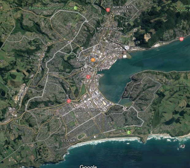
If we thought the devastation and mess caused by a flood ripping through the old dump at Fox Glacier village was bad, just wait until a decent storm punches through the old dump of New Zealand’s fifth largest city on its coastline. It’s getting close.
Dunedin is now preparing to have the massive Kettle Park dump exposed to the sea.
It was previously a sand dune system, and has encroached into the sea over the last century.
But it looks like the sea wants it back.
It’s not like they weren’t warned. In 2015 the whole of South Dunedin underwent massive flooding, not assisted by poorly maintained DCC stormwater drains. I am aware of people whose houses were devastated by that storm that are still gradually recovering.
South Dunedin is also on average home to some of the poorest and most deprived people in New Zealand.
It’s not the paradise first advertised.
I no longer care whether it’s called climate change or the weather. I’m sure there are differences of timescale.
As The Otago Daily Times noted in 2017, most of South Dunedin is under threat from sea level rise, and some of it is under sea water table already.
If this rubbish dump gets exposed, the next thing to go will be the entire racecourse.
After which it’s harder to stop a whole bunch of houses with people in them getting less viable.
Cities that prepare for managed retreat with big plans that help their citizens move will have a better chance than most.
Here comes the next warning.
75 comments on “Dunedin South as Next Fox River Dump Disaster? ”
- Comments are now closed
- Comments are now closed
Recent Comments
- Winston Peters delivers a speech about NZ’s relationship with China but media focus on Bob Carr’...
 Buzz from the Beehive Much more media attention is being paid to something Winston Peters said about former Australian Foreign Minister Bob Carr than to a speech he delivered to the New Zealand China Council. One word is missing from the speech: AUKUS. But AUKUS loomed large in his considerations ...6 hours ago
 - The Post-Covid Economy
 Is the economy in another long stagnation? If so, why?This is about the time that the Treasury will be locking up its economic forecasts to be published in the 2024 Budget Economic and Fiscal Update (BEFU) on budget day, 30 May. I am not privy to what they will be ...6 hours ago
 - An awkward coincidence!
 The annual list of who's been bribing our politicians is out, and journalists will no doubt be poring over it to find the juiciest and dirtiest bribes. The government's fast-track invite list is likely to be a particular focus, and we already know of one company on the list which ...8 hours ago
 - The Israel/Palestinian metastasis.
 In the weeks after the October 7 Hamas attacks on Southern Israel I wrote about the possible 2nd, 3rd and even 4th order effects of the conflict. These included new fronts being opened in the West Bank (with Hamas), Golan … Continue reading ...9 hours ago
 - 27,000That's the number of submissions received on National's corrupt Muldoonist fast-track legislation. Except its higher than that, because the number doesn't include form submissions, such as the 15,000 people who supported Forest & Bird's submission, or the 14,000 who supported Greenpeace. And so many people want to appear in person ...12 hours ago
- MPs’ salaries – when is the best time to increase them?
 Peter Dunne writes – It is one of the oldest truisms that there is never a good time for MPs to get a pay rise. This week’s announcement of pay raises of around 2.8% backdated to last October could hardly have come at a worse time, with the ...12 hours ago
 - Genter under fireDavid Farrar writes – Newshub reports: Newshub can reveal a fresh allegation of intimidation against Green MP Julie-Anne Genter. Genter is subject to a disciplinary process for aggressively waving a book in the face of National Minister Matt Doocey in the House – but it’s not the first time ...12 hours ago
- New Treasury paper on the productivity slowdown supports the downgrading of forecastsThe Treasury has published a paper today on the global productivity slowdown and how it is playing out in New Zealand: The productivity slowdown: implications for the Treasury’s forecasts and projections. The Treasury Paper examines recent trends in productivity and the potential drivers of the slowdown. Productivity for the whole economy ...12 hours ago
- Bernard’s pick 'n' mix for Friday, May 3
 TL;DR: Here’s my top 10 ‘pick ‘n’ mix of links to news, analysis and opinion articles as of 9:26 am on Friday, May 3:Climate 'Ministerial override must go' - Hearings begin over fast-track bill RNZ Kate GreenPopulation: Labour hire firm struggling to find staff as Australia lures away workers. HireStaff ...15 hours ago
 - Weekly Roundup 3-May-2024
 Here we are in May already! And here are a few of the stories that caught our eye this week. This Week on Greater Auckland On Monday, Matt highlighted that it’s been a decade since Auckland’s rail system was electrified. On Wednesday, Matt looked at AT’s rollout of new ways ...16 hours ago
 - The Hoon around the week to May 316 hours ago
- Pamphlets at Ten Paces.
 These puppet strings don't pull themselvesYou're thinking thoughts from someone elseHow much time do you think you have?Are you prepared for what comes next?The debating chamber can be a trying place for an opposition MP. What with the person in charge, the speaker, typically being an MP from the governing ...17 hours ago
 - A land without pier
 The land around Lyme Regis, where Meryl Streep once stood, in a hood, on the Cobb, is falling into the sea.MerylThe land around Lyme Regis, around the Cobb that made it rich, has always been falling slowly but surely into the sea. Read more ...17 hours ago
 - Skeptical Science New Research for Week #18 2024
 Open access notables Generative AI tools can enhance climate literacy but must be checked for biases and inaccuracies, Atkins et al., Communications Earth & Environment: In the face of climate change, climate literacy is becoming increasingly important. With wide access to generative AI tools, such as OpenAI’s ChatGPT, we explore the potential ...1 day ago
 - Ruckus over AUKUS – Labour demands Peters step down as Foreign Minister, but he still had the job ...Buzz from the Beehive Foreign Affairs Minister Winston Peters was bound to win headlines when he set out his thinking about AUKUS in his speech to the New Zealand Institute of International Affairs. The headlines became bigger when – during an interview on RNZ’s Morning Report today – he criticised ...1 day ago
- Secrecy undermines participationThe Post reports on how the government is refusing to release its advice on its corrupt Muldoonist fast-track law, instead using the "soon to be publicly available" refusal ground to hide it until after select committee submissions on the bill have closed. Fast-track Minister Chris Bishop's excuse? “It's not ...1 day ago
- Agribusiness following oil and gas playbookAs pressure on it grows, the livestock industry’s approach to the transition to Net Zero is increasingly being compared to that of fossil fuel interests. Photo: Lynn Grieveson / Getty ImagesTL;DR: Here’s the top five news items of note in climate news for Aotearoa-NZ this week, and a discussion above ...1 day ago
- Here’s hoping they aren’t counting on a 100 per cent acceptance…The New Zealand Herald reports – Stats NZ has offered a voluntary redundancy scheme to all of its workers as a way to give staff some control over their “future” amidst widespread job losses in the public sector. In an update to staff this morning, seen by the Herald, Statistics New Zealand ...1 day ago
- Gordon Campbell on unemployment, Winston Peters’ low boiling point and music criticism
 On Werewolf/Scoop, I usually do two long form political columns a week. From now on, there will be an extra column each week about music and movies. But first, some late-breaking political events: The rise in unemployment numbers for the March quarter was bigger than expected – and especially sharp ...1 day ago
 - TVNZ and poll results1 day ago
- Mana or MoneyMuriel Newman writes – When Meridian Energy was seeking resource consents for a West Coast hydro dam proposal in 2010, local Maori “strenuously” objected, claiming their mana was inextricably linked to ‘their’ river and could be damaged. After receiving a financial payment from the company, however, the Ngai Tahu ...2 days ago
- Bernard’s pick 'n' mix for Thursday, May 2
 TL;DR: Here’s my top 10 ‘pick ‘n’ mix of links to news, analysis and opinion articles as of 11:10 am on Thursday, May 2:Scoop: Government sits on official advice on fast-track consent. The Ombudsman is investigating after official briefings on the contentious regime were held back despite requests from Forest ...2 days ago
 - The Art of taking no ResponsibilityAlwyn Poole writes – “An SEP,’ he said, ‘is something that we can’t see, or don’t see, or our brain doesn’t let us see, because we think that it’s somebody else’s problem. That’s what SEP means. Somebody Else’s Problem. The brain just edits it out, it’s like a ...2 days ago
- The shabby “Parliamentary urgency” ploy – shaky foundations and why our democracy needs trustOur trust in our political institutions is fast eroding, according to a Maxim Institute discussion paper, Shaky Foundations: Why our democracy needs trust. The paper – released today – raises concerns about declining trust in New Zealand’s political institutions and democratic processes, and the role that the overuse of Parliamentary urgency ...2 days ago
- Jones has made plain he isn’t fond of frogs (not the dim-witted ones, at least) – and now we lea...This article was prepared for publication yesterday. More ministerial announcements have been posted on the government’s official website since it was written. We will report on these later today …. Buzz from the Beehive There we were, thinking the environment is in trouble, when along came Jones. Shane Jones. ...2 days ago
- Infrastructure & home building slumping on Govt funding freeze
 2 days ago
 - Brainwashed People Think Everyone Else is Brainwashed
 Hi,I am just going to state something very obvious: American police are fucking crazy.That was a photo gracing the New York Times this morning, showing New York City police “entering Columbia University last night after receiving a request from the school.”Apparently in America, protesting the deaths of tens of thousands ...2 days ago
 - Peters’ real foreign policy threat is Helen ClarkWinston Peters’ much anticipated foreign policy speech last night was a work of two halves. Much of it was a standard “boilerplate” Foreign Ministry overview of the state of the world. There was some hardening up of rhetoric with talk of “benign” becoming “malign” and old truths giving way to ...2 days ago
- NZ’s trans lobby is fighting a rearguard action
 Graham Adams assesses the fallout of the Cass Review — The press release last Thursday from the UN Special Rapporteur on violence against women and girls didn’t make the mainstream news in New Zealand but it really should have. The startling title of Reem Alsalem’s statement — “Implementation of ‘Cass ...2 days ago
 - Your mandate is imaginary
 This open-for-business, under-new-management cliché-pockmarked government of Christopher Luxon is not the thing of beauty he imagines it to be. It is not the powerful expression of the will of the people that he asserts it to be. It is not a soaring eagle, it is a malodorous vulture. This newest poll should make ...2 days ago
 - 14,000 unemployed under NationalThe latest labour market statistics, showing a rise in unemployment. There are now 134,000 unemployed - 14,000 more than when the National government took office. Which is I guess what happens when the Reserve Bank causes a recession in an effort to Keep Wages Low. The previous government saw a ...2 days ago
- Bryce Edwards: Discontent and gloom dominate NZ’s political mood
 Three opinion polls have been released in the last two days, all showing that the new government is failing to hold their popular support. The usual honeymoon experienced during the first year of a first term government is entirely absent. The political mood is still gloomy and discontented, mainly due ...2 days ago
 - Taking Tea with 42 & 38.
 National's Finance Minister once met a poor person.A scornful interview with National's finance guru who knows next to nothing about economics or people.There might have been something a bit familiar if that was the headline I’d gone with today. It would of course have been in tribute to the article ...2 days ago
 - Beware political propaganda: statistics are pointing to Grant Robertson never protecting “Lives an...Rob MacCulloch writes – Throughout the pandemic, the new Vice-Chancellor-of-Otago-University-on-$629,000 per annum-Can-you-believe-it-and-Former-Finance-Minister Grant Robertson repeated the mantra over and over that he saved “lives and livelihoods”. As we update how this claim is faring over the course of time, the facts are increasingly speaking differently. NZ ...2 days ago
- Winding back the hands of history’s clockChris Trotter writes – IT’S A COMMONPLACE of political speeches, especially those delivered in acknowledgement of electoral victory: “We’ll govern for all New Zealanders.” On the face of it, the pledge is a strange one. Why would any political leader govern in ways that advantaged the huge ...2 days ago
- Paula Bennett’s political appointment will challenge public confidence
 Bryce Edwards writes – The list of former National Party Ministers being given plum and important roles got longer this week with the appointment of former Deputy Prime Minister Paula Bennett as the chair of Pharmac. The Christopher Luxon-led Government has now made key appointments to Bill ...3 days ago
 - Business confidence sliding into winter of discontentTL;DR: These are the six things that stood out to me in news and commentary on Aotearoa-NZ’s political economy at 10:06am on Wednesday, May 1:The Lead: Business confidence fell across the board in April, falling in some areas to levels last seen during the lockdowns because of a collapse in ...3 days ago
- Gordon Campbell on the coalition’s awful, not good, very bad poll resultsOver the past 36 hours, Christopher Luxon has been dong his best to portray the centre-right’s plummeting poll numbers as a mark of virtue. Allegedly, the negative verdicts are the result of hard economic times, and of a government bravely set out on a perilous rescue mission from which not ...3 days ago
- New HOP readers for future payment optionsAuckland Transport have started rolling out new HOP card readers around the network and over the next three months, all of them on buses, at train stations and ferry wharves will be replaced. The change itself is not that remarkable, with the new readers looking similar to what is already ...3 days ago
- 2024 Reading Summary: April (+ Writing Update)
 Completed reads for April: The Difference Engine, by William Gibson and Bruce Sterling Carnival of Saints, by George Herman The Snow Spider, by Jenny Nimmo Emlyn’s Moon, by Jenny Nimmo The Chestnut Soldier, by Jenny Nimmo Death Comes As the End, by Agatha Christie Lord of the Flies, by ...3 days ago
 - At a glance – Clearing up misconceptions regarding 'hide the decline'On February 14, 2023 we announced our Rebuttal Update Project. This included an ask for feedback about the added "At a glance" section in the updated basic rebuttal versions. This weekly blog post series highlights this new section of one of the updated basic rebuttal versions and serves as a ...3 days ago
- Road photos
 Have a story to share about St Paul’s, but today just picturesPopular novels written at this desk by a young man who managed to bootstrap himself out of father’s imprisonment and his own young life in a workhouse Read more ...3 days ago
 - Bryce Edwards: Paula Bennett’s political appointment will challenge public confidenceThe list of former National Party Ministers being given plum and important roles got longer this week with the appointment of former Deputy Prime Minister Paula Bennett as the chair of Pharmac. The Christopher Luxon-led Government has now made key appointments to Bill English, Simon Bridges, Steven Joyce, Roger Sowry, ...3 days ago
- NZDF is still hostile to oversightNewsroom has a story today about National's (fortunately failed) effort to disestablish the newly-created Inspector-General of Defence. The creation of this agency was the key recommendation of the Inquiry into Operation Burnham, and a vital means of restoring credibility and social licence to an agency which had been caught lying ...3 days ago
- Winding Back The Hands Of History’s Clock.
 Holding On To The Present: The moment a political movement arises that attacks the whole idea of social progress, and announces its intention to wind back the hands of History’s clock, then democracy, along with its unwritten rules, is in mortal danger.IT’S A COMMONPLACE of political speeches, especially those delivered in ...3 days ago
 - Sweet Moderation? What Christopher Luxon Could Learn From The Germans.3 days ago
- A clear warningThe unpopular coalition government is currently rushing to repeal section 7AA of the Oranga Tamariki Act. The clause is Oranga Tamariki's Treaty clause, and was inserted after its systematic stealing of Māori children became a public scandal and resulted in physical resistance to further abductions. The clause created clear obligations ...3 days ago
- Poll results and Waitangi Tribunal report go unmentioned on the Beehive website – where racing tru...Buzz from the Beehive The government’s official website – which Point of Order monitors daily – not for the first time has nothing much to say today about political happenings that are grabbing media headlines. It makes no mention of the latest 1News-Verian poll, for example. This shows National down ...3 days ago
- Listening To The Traffic.3 days ago
- Comity Be Damned! The State’s Legislative Arm Is Flexing Its Constitutional Muscles.Packing A Punch: The election of the present government, including in its ranks politicians dedicated to reasserting the rights of the legislature in shaping and determining the future of Māori and Pakeha in New Zealand, should have alerted the judiciary – including its anomalous appendage, the Waitangi Tribunal – that its ...3 days ago
- Ending The Quest.Dead Woman Walking: New Zealand’s media industry had been moving steadily towards disaster for all the years Melissa Lee had been National’s media and communications policy spokesperson, and yet, when the crisis finally broke, on her watch, she had nothing intelligent to offer. Christopher Luxon is a patient man - but he’s not ...3 days ago
- Will political polarisation intensify to the point where ‘normal’ government becomes impossible,...Chris Trotter writes – New Zealand politics is remarkably easy-going: dangerously so, one might even say. With the notable exception of John Key’s flat ruling-out of the NZ First Party in 2008, all parties capable of clearing MMP’s five-percent threshold, or winning one or more electorate seats, tend ...3 days ago
- Bernard’s pick 'n' mix for Tuesday, April 30
 TL;DR: Here’s my top 10 ‘pick ‘n’ mix of links to news, analysis and opinion articles as of 10:30am on Tuesday, May 30:Scoop: NZ 'close to the tipping point' of measles epidemic, health experts warn NZ Herald Benjamin PlummerHealth: 'Absurd and totally unacceptable': Man has to wait a year for ...4 days ago
 - Why Tory Whanau has the lowest approval rating in the countryBryce Edwards writes – Polling shows that Wellington Mayor Tory Whanau has the lowest approval rating of any mayor in the country. Siting at -12 per cent, the proportion of constituents who disapprove of her performance outweighs those who give her the thumbs up. This negative rating is ...4 days ago
- Worst poll result for a new Government in MMP history4 days ago
- Pinning down climate change's role in extreme weatherThis is a re-post from The Climate Brink by Andrew Dessler In the wake of any unusual weather event, someone inevitably asks, “Did climate change cause this?” In the most literal sense, that answer is almost always no. Climate change is never the sole cause of hurricanes, heat waves, droughts, or ...4 days ago
- Serving at Seymour's pleasure.
 Something odd happened yesterday, and I’d love to know if there’s more to it. If there was something which preempted what happened, or if it was simply a throwaway line in response to a journalist.Yesterday David Seymour was asked at a press conference what the process would be if the ...4 days ago
 - Webworm LA Pop-Up
 Hi,From time to time, I want to bring Webworm into the real world. We did it last year with the Jurassic Park event in New Zealand — which was a lot of fun!And so on Saturday May 11th, in Los Angeles, I am hosting a lil’ Webworm pop-up! I’ve been ...4 days ago
 - “Feel good” school is outEducation Minister Erica Standford yesterday unveiled a fundamental reform of the way our school pupils are taught. She would not exactly say so, but she is all but dismantling the so-called “inquiry” “feel good” method of teaching, which has ruled in our classrooms since a major review of the New ...4 days ago
- 6 Months in, surely our Report Card is “Ignored all warnings: recommend dismissal ASAP”?
 Exactly where are we seriously going with this government and its policies? That is, apart from following what may as well be a Truss-Lite approach on the purported economic “plan“, and Victorian-era regression when it comes to social policy. Oh it’ll work this time of course, we’re basically assured, “the ...4 days ago
 - Bread, and how it gets buttered
 Hey Uncle Dave, When the Poms joined the EEC, I wasn't one of those defeatists who said, Well, that’s it for the dairy job. And I was right, eh? The Chinese can’t get enough of our milk powder and eventually, the Poms came to their senses and backed up the ute ...4 days ago
 - Bryce Edwards: Why Tory Whanau has the lowest approval rating in the countryPolling shows that Wellington Mayor Tory Whanau has the lowest approval rating of any mayor in the country. Siting at -12 per cent, the proportion of constituents who disapprove of her performance outweighs those who give her the thumbs up. This negative rating is higher than for any other mayor ...4 days ago
- Justice for Gaza?The New York Times reports that the International Criminal Court is about to issue arrest warrants for Israeli officials, including Prime Minister Benjamin Netanyahu, over their genocide in Gaza: Israeli officials increasingly believe that the International Criminal Court is preparing to issue arrest warrants for senior government officials on ...4 days ago
- If there has been any fiddling with Pharmac’s funding, we can count on Paula to figure out the fis...Buzz from the Beehive Pharmac has been given a financial transfusion and a new chair to oversee its spending in the pharmaceutical business. Associate Health Minister David Seymour described the funding for Pharmac as “its largest ever budget of $6.294 billion over four years, fixing a $1.774 billion fiscal cliff”. ...4 days ago
- FastTrackWatch – The case for the Government’s Fast Track BillBryce Edwards writes – Many criticisms are being made of the Government’s Fast Track Approvals Bill, including by this writer. But as with everything in politics, every story has two sides, and both deserve attention. It’s important to understand what the Government is trying to achieve and its ...5 days ago
- Bernard’s pick 'n' mix for Monday, April 29
 TL;DR: Here’s my top 10 ‘pick ‘n’ mix of links to news, analysis and opinion articles as of 10:10am on Monday, April 29:Scoop: The children's ward at Rotorua Hospital will be missing a third of its beds as winter hits because Te Whatu Ora halted an upgrade partway through to ...5 days ago
 - Gordon Campbell on Iran killing its rappers, and searching for the invisible Dr. Retispan class=”dropcap”>As hideous as David Seymour can be, it is worth keeping in mind occasionally that there are even worse political figures (and regimes) out there. Iran for instance, is about to execute the country’s leading hip hop musician Toomaj Salehi, for writing and performing raps that “corrupt” the nation’s ...5 days ago
- Auckland Rail Electrification 10 years oldYesterday marked 10 years since the first electric train carried passengers in Auckland so it’s a good time to look back at it and the impact it has had. A brief history The first proposals for rail electrification in Auckland came in the 1920’s alongside the plans for earlier ...5 days ago
- Coalition's dirge of austerity and uncertainty is driving the economy into a deeper recession5 days ago
- Disability Funding or Tax Cuts.
 You make people evil to punish the paststuck inside a sequel with a rotating castThe following photos haven’t been generated with AI, or modified in any way. They are flesh and blood, human beings. On the left is Galatea Young, a young mum, and her daughter Fiadh who has Angelman ...5 days ago
 - Of the Goodness of Tolkien’s Eru
 April has been a quiet month at A Phuulish Fellow. I have had an exceptionally good reading month, and a decently productive writing month – for original fiction, anyway – but not much has caught my eye that suggested a blog article. It has been vaguely frustrating, to be honest. ...5 days ago
 - 2024 SkS Weekly Climate Change & Global Warming News Roundup #17A listing of 31 news and opinion articles we found interesting and shared on social media during the past week: Sun, April 21, 2024 thru Sat, April 27, 2024. Story of the week Anthropogenic climate change may be the ultimate shaggy dog story— but with a twist, because here ...5 days ago
- Pastor Who Abused People, Blames People
 Hi,I spent about a year on Webworm reporting on an abusive megachurch called Arise, and it made me want to stab my eyes out with a fork.I don’t regret that reporting in 2022 and 2023 — I am proud of it — but it made me angry.Over three main stories ...5 days ago
 - Vic Uni shows how under threat free speech isThe new Victoria University Vice-Chancellor decided to have a forum at the university about free speech and academic freedom as it is obviously a topical issue, and the Government is looking at legislating some carrots or sticks for universities to uphold their obligations under the Education and Training Act. They ...6 days ago
- Winston remembers Gettysburg.
 Do you remember when Melania Trump got caught out using a speech that sounded awfully like one Michelle Obama had given? Uncannily so.Well it turns out that Abraham Lincoln is to Winston Peters as Michelle was to Melania. With the ANZAC speech Uncle Winston gave at Gallipoli having much in ...6 days ago
- Release: National gaslights women fighting for equal pay
 National has scrapped the pay equity taskforce that fights for equal pay for women and looks at ethnic pay gaps. ...1 day ago
 - Release: More job cuts, fewer houses under NationalThe Government is again adding to New Zealand’s growing unemployment, this time cutting jobs at the agencies responsible for urban development and growing much needed housing stock. ...1 day ago
- Release: Children fall deeper through the cracks in Govt cutsWith Minister Karen Chhour indicating in the House today that she either doesn’t know or care about the frontline cuts she’s making to Oranga Tamariki, we risk seeing more and more of our children falling through the cracks. ...1 day ago
- Release: Labour honours memory of Sir Robert MartinThe Labour Party is saddened to learn of the death of Sir Robert Martin, a globally renowned disability advocate who led the way for disability rights both in New Zealand and internationally. ...2 days ago
- Release: 130,000 cattle saved from live exportLabour is calling for the Government to urgently rethink its coalition commitment to restart live animal exports, Labour animal welfare spokesperson Rachel Boyack said. ...2 days ago
- Central Bank makes clear Government is pouring fuel on housing crisis fire
 Today’s Financial Stability Report has once again highlighted that poverty and deep inequality are political choices - and this Government is choosing to make them worse. ...2 days ago
 - New unemployment figures paint bleak pictureThe Green Party is calling on the Government to do more for our households in most need as unemployment rises and the cost of living crisis endures. ...2 days ago
- Release: National’s job cuts already starting to bite as unemployment risesUnemployment is on the rise and it’s only going to get worse under this Government, Labour finance spokesperson Barbara Edmonds said. Stats NZ figures show the unemployment rate grew to 4.3 percent in the March quarter from 4 percent in the December quarter. “This is the second rise in unemployment ...2 days ago
- Release: National hiking transport costs for families and young New ZealandersWeekly expenses will grow for more than 1.6 million New Zealanders as the Government ends free and half price public transport fares tomorrow. ...3 days ago
- Release: Labour welcomes EU free trade agreementThe New Zealand Labour Party welcomes the entering into force of the European Union and New Zealand free trade agreement. This agreement opens the door for a huge increase in trade opportunities with a market of 450 million people who are high value discerning consumers of New Zealand goods and ...3 days ago
- Surprise: Landlord tax cuts don’t trickle downThe Green Party is renewing its call for rent controls following reports of rental prices hitting an all-time high. ...4 days ago
- Release: $1.7b for no increase in access to medicineThe National-led Government continues its fiscal jiggery pokery with its Pharmac announcement today, Labour Health spokesperson Ayesha Verrall says. “The government has increased Pharmac funding but conceded it will only make minimal increases in access to medicine”, said Ayesha Verrall “This is far from the bold promises made to fund ...4 days ago
- Release: National should heed Tribunal warning and scrap coalition commitment with ACTThis afternoon’s interim Waitangi Tribunal report must be taken seriously as it affects our most vulnerable children, Labour children’s spokesperson Willow-Jean Prime. ...4 days ago
- Release: More accountability for preventable workplace deaths this Workers’ Memorial DayLabour is calling for more accountability for preventable workplace deaths because everybody who goes to work deserves to come home safely. ...5 days ago
- Gaza: Aotearoa Must Support Independent Investigation into Mass GravesTe Pāti Māori are demanding the New Zealand Government support an international independent investigation into mass graves that have been uncovered at two hospitals on the Gaza strip, following weeks of assault by Israeli troops. Among the 392 bodies that have been recovered, are children and elderly civilians. Many of ...1 week ago
- Release: Working together on consistent support for veterans this Anzac DayOur two-tiered system for veterans’ support is out of step with our closest partners, and all parties in Parliament should work together to fix it, Labour veterans’ affairs spokesperson Greg O’Connor said. ...1 week ago
- Release: Penny drops – but what about Seymour and Peters?Stripping two Ministers of their portfolios just six months into the job shows Christopher Luxon’s management style is lacking, Labour Leader Chris Hipkins said. ...1 week ago
- Another ‘Stolen Generation’ enabled by court ruling on Waitangi Tribunal summonsTonight’s court decision to overturn the summons of the Children’s Minister has enabled the Crown to continue making decisions about Māori without evidence, says Te Pāti Māori spokesperson for Children, Mariameno Kapa-Kingi. “The judicial system has this evening told the nation that this government can do whatever they want when ...1 week ago
- Release: Budget blunder shows Nicola Willis could cut recovery fundingIt appears Nicola Willis is about to pull the rug out from under the feet of local communities still dealing with the aftermath of last year’s severe weather, and local councils relying on funding to build back from these disasters. ...1 week ago
- Further environmental mismanagement on the cardsThe Government’s resource management reforms will add to the heavy and ever-growing burden this Government is loading on to our environment. ...1 week ago
- Release: RMA changes will be a disaster for environmentThe Government is making short-sighted changes to the Resource Management Act (RMA) that will take away environmental protection in favour of short-term profits, Labour’s environment spokesperson Rachel Brooking said today. ...2 weeks ago
- Release: Labour supports urgent changes to emergency management systemLabour welcomes the release of the report into the North Island weather events and looks forward to working with the Government to ensure that New Zealand is as prepared as it can be for the next natural disaster. ...2 weeks ago
- Release: Labour calls for New Zealand to recognise PalestineThe Labour Party has called for the New Zealand Government to recognise Palestine, as a material step towards progressing the two-State solution needed to achieve a lasting peace in the region. ...2 weeks ago
- Release: Three strikes law political posturing of worst kindThe Government is bringing back a law that has little evidential backing just to look tough, Labour justice spokesperson Duncan Webb said. ...2 weeks ago
- Release: Government cuts unbelievably target child exploitation, violent extremism, ports and airpor...Some of our country’s most important work, stopping the sexual exploitation of children and violent extremism could go along with staff on the frontline at ports and airports. ...2 weeks ago
- Three strikes has failed before and will fail againResurrecting the archaic three-strikes legislation is an unwelcome return to a failed American-style approach to justice. ...2 weeks ago
- Release: Environmental protection vital, not ‘onerous’The Government’s Fast Track Approvals Bill will give projects such as new coal mines a ‘get out of jail free’ card to wreak havoc on the environment, Labour Leader Chris Hipkins said today. ...2 weeks ago
- Ferris – Three Strikes targets those ‘too brown to be white’The government's decision to reintroduce Three Strikes is a destructive and ineffective piece of law-making that will only exacerbate an inherently biased and racist criminal justice system, said Te Pāti Māori Justice Spokesperson, Tākuta Ferris, today. During the time Three Strikes was in place in Aotearoa, Māori and Pasifika received ...2 weeks ago
- Release: Govt cuts doctors and nurses in hiring freezeCuts to frontline hospital staff are not only a broken election promise, it shows the reckless tax cuts have well and truly hit the frontline of the health system, says Labour Health spokesperson Ayesha Verrall. ...2 weeks ago
- Fast-track submissions period must be extendedThe Green Party has joined the call for public submissions on the fast-track legislation to be extended after the Ombudsman forced the Government to release the list of organisations invited to apply just hours before submissions close. ...2 weeks ago
- Release: Progress on climate will be undone by GovtNew Zealand’s good work at reducing climate emissions for three years in a row will be undone by the National government’s lack of ambition and scrapping programmes that were making a difference, Labour Party climate spokesperson Megan Woods said today. ...2 weeks ago
- Release: Dark day for Kiwi kids as a third of Govt cuts affect themNews that 1000 jobs at the Ministry of Education and Oranga Tamariki could go is devastating for future generations of New Zealanders. ...2 weeks ago
- Release: Alarm as Government signals further blow to school lunchesMore essential jobs could be on the chopping block, this time Ministry of Education staff on the school lunches team are set to find out whether they're in line to lose their jobs. ...2 weeks ago
- Oranga Tamariki cuts commit tamariki to state abuseTe Pāti Māori is disgusted at the confirmation that hundreds are set to lose their jobs at Oranga Tamariki, and the disestablishment of the Treaty Response Unit. “This act of absolute carelessness and out of touch decision making is committing tamariki to state abuse.” Said Te Pāti Māori Oranga Tamariki ...2 weeks ago
- Release: Quick, submit – stop Govt’s dodgy approvals billThe Government is trying to bring in a law that will allow Ministers to cut corners and kill off native species, Labour environment spokesperson Rachel Brooking said. ...2 weeks ago
- Government throws coal on the climate crisis fireThe Government’s policy announced today to ease consenting for coal mining will have a lasting impact across generations. ...3 weeks ago
- Release: Public transport costs to double as National looks at unaffordable roading project insteadCancelling urgently needed new Cook Strait ferries and hiking the cost of public transport for many Kiwis so that National can announce the prospect of another tunnel for Wellington is not making good choices, Labour Transport Spokesperson Tangi Utikere said. ...3 weeks ago
- Release: Cost of living in Auckland still not a priorityA laundry list of additional costs for Tāmaki Makarau Auckland shows the Minister for the city is not delivering for the people who live there, says Labour Auckland Issues spokesperson Shanan Halbert. ...3 weeks ago
- Te Pāti Māori to visit Queensland to strengthen ties with Māori in AustraliaTe Pāti Māori co-leader Rawiri Waititi, and Mema Paremata mō Tāmaki-Makaurau, Takutai Tarsh Kemp, will travel to the Gold Coast to strengthen ties with Māori in Australia next week (15-21 April). The visit, in the lead-up to the 9th Australian National Kapa haka Festival, will be an opportunity for both ...3 weeks ago
- Decision allows for housing growth in Western Bay of Plenty
 The Minister Responsible for RMA Reform, Chris Bishop today released his decision on four recommendations referred to him by the Western Bay of Plenty District Council, opening the door to housing growth in the area. The Council’s Plan Change 92 allows more homes to be built in existing and new ...12 hours ago
 - Speech to New Zealand China CouncilThank you, John McKinnon and the New Zealand China Council for the invitation to speak to you today. Thank you too, all members of the China Council. Your effort has played an essential role in helping to build, shape, and grow a balanced and resilient relationship between our two ...15 hours ago
- Modern insurance law will protect Kiwi householdsThe Government is modernising insurance law to better protect Kiwis and provide security in the event of a disaster, Commerce and Consumer Affairs Minister Andrew Bayly announced today. “These reforms are long overdue. New Zealand’s insurance law is complicated and dated, some of which is more than 100 years old. ...1 day ago
- Government recommits to equal payThe coalition Government is refreshing its approach to supporting pay equity claims as time-limited funding for the Pay Equity Taskforce comes to an end, Public Service Minister Nicola Willis says. “Three years ago, the then-government introduced changes to the Equal Pay Act to support pay equity bargaining. The changes were ...1 day ago
- Transforming how our children learn to readStructured literacy will change the way New Zealand children learn to read - improving achievement and setting students up for success, Education Minister Erica Stanford says. “Being able to read and write is a fundamental life skill that too many young people are missing out on. Recent data shows that ...1 day ago
- NZ not backing down in Canada dairy disputeTrade Minister Todd McClay says Canada’s refusal to comply in full with a CPTPP trade dispute ruling in our favour over dairy trade is cynical and New Zealand has no intention of backing down. Mr McClay said he has asked for urgent legal advice in respect of our ‘next move’ ...2 days ago
- Stronger oversight for our most vulnerable childrenThe rights of our children and young people will be enhanced by changes the coalition Government will make to strengthen oversight of the Oranga Tamariki system, including restoring a single Children’s Commissioner. “The Government is committed to delivering better public services that care for our most at-risk young people and ...2 days ago
- Streamlining Building Consent ChangesThe Government is making it easier for minor changes to be made to a building consent so building a home is easier and more affordable, Building and Construction Minister Chris Penk says. “The coalition Government is focused on making it easier and cheaper to build homes so we can ...2 days ago
- Minister acknowledges passing of Sir Robert Martin (KNZM)New Zealand lost a true legend when internationally renowned disability advocate Sir Robert Martin (KNZM) passed away at his home in Whanganui last night, Disabilities Issues Minister Louise Upston says. “Our Government’s thoughts are with his wife Lynda, family and community, those he has worked with, the disability community in ...2 days ago
- Speech to New Zealand Institute of International Affairs, Parliament – Annual Lecture: Challenges ...Good evening – Before discussing the challenges and opportunities facing New Zealand’s foreign policy, we’d like to first acknowledge the New Zealand Institute of International Affairs. You have contributed to debates about New Zealand foreign policy over a long period of time, and we thank you for hosting us. ...2 days ago
- Accelerating airport security linesFrom today, passengers travelling internationally from Auckland Airport will be able to keep laptops and liquids in their carry-on bags for security screening thanks to new technology, Transport Minister Simeon Brown says. “Creating a more efficient and seamless travel experience is important for holidaymakers and businesses, enabling faster movement through ...2 days ago
- Community hui to talk about kina barrensPeople with an interest in the health of Northland’s marine ecosystems are invited to a public meeting to discuss how to deal with kina barrens, Oceans and Fisheries Minister Shane Jones says. Mr Jones will lead the discussion, which will take place on Friday, 10 May, at Awanui Hotel in ...3 days ago
- Kiwi exporters win as NZ-EU FTA enters into forceKiwi exporters are $100 million better off today with the NZ EU FTA entering into force says Trade Minister Todd McClay. “This is all part of our plan to grow the economy. New Zealand's prosperity depends on international trade, making up 60 per cent of the country’s total economic activity. ...3 days ago
- Mining resurgence a welcome signThere are heartening signs that the extractive sector is once again becoming an attractive prospect for investors and a source of economic prosperity for New Zealand, Resources Minister Shane Jones says. “The beginnings of a resurgence in extractive industries are apparent in media reports of the sector in the past ...3 days ago
- Ō-Rākau Remembrance Bill passes first readingThe return of the historic Ō-Rākau battle site to the descendants of those who fought there moved one step closer today with the first reading of Te Pire mō Ō-Rākau, Te Pae o Maumahara / The Ō-Rākau Remembrance Bill. The Bill will entrust the 9.7-hectare battle site, five kilometres west ...3 days ago
- Government to boost public EV charging networkEnergy Minister Simeon Brown has announced 25 new high-speed EV charging hubs along key routes between major urban centres and outlined the Government’s plan to supercharge New Zealand’s EV infrastructure. The hubs will each have several chargers and be capable of charging at least four – and up to 10 ...3 days ago
- Residential Property Managers Bill to not progressThe coalition Government will not proceed with the previous Government’s plans to regulate residential property managers, Housing Minister Chris Bishop says. “I have written to the Chairperson of the Social Services and Community Committee to inform him that the Government does not intend to support the Residential Property Managers Bill ...3 days ago
- Independent review into disability support servicesThe Government has announced an independent review into the disability support system funded by the Ministry of Disabled People – Whaikaha. Disability Issues Minister Louise Upston says the review will look at what can be done to strengthen the long-term sustainability of Disability Support Services to provide disabled people and ...4 days ago
- Justice Minister updates UN on law & order planJustice Minister Paul Goldsmith has attended the Universal Periodic Review in Geneva and outlined the Government’s plan to restore law and order. “Speaking to the United Nations Human Rights Council provided us with an opportunity to present New Zealand’s human rights progress, priorities, and challenges, while responding to issues and ...4 days ago
- Ending emergency housing motels in RotoruaThe Government and Rotorua Lakes Council are committed to working closely together to end the use of contracted emergency housing motels in Rotorua. Associate Minister of Housing (Social Housing) Tama Potaka says the Government remains committed to ending the long-term use of contracted emergency housing motels in Rotorua by the ...4 days ago
- Trade Minister travels to Riyadh, OECD, and DubaiTrade Minister Todd McClay heads overseas today for high-level trade talks in the Gulf region, and a key OECD meeting in Paris. Mr McClay will travel to Riyadh to meet with counterparts from Saudi Arabia and the Gulf Cooperation Council (GCC). “New Zealand’s goods and services exports to the Gulf region ...4 days ago
- Education priorities focused on lifting achievementEducation Minister Erica Stanford has outlined six education priorities to deliver a world-leading education system that sets Kiwi kids up for future success. “I’m putting ambition, achievement and outcomes at the heart of our education system. I want every child to be inspired and engaged in their learning so they ...4 days ago
- NZTA App first step towards digital driver licenceThe new NZ Transport Agency (NZTA) App is a secure ‘one stop shop’ to provide the services drivers need, Transport Minister Simeon Brown and Digitising Government Minister Judith Collins say. “The NZTA App will enable an easier way for Kiwis to pay for Vehicle Registration and Road User Charges (RUC). ...4 days ago
- Supporting whānau out of emergency housingWhānau with tamariki growing up in emergency housing motels will be prioritised for social housing starting this week, says Associate Housing Minister Tama Potaka. “Giving these whānau a better opportunity to build healthy stable lives for themselves and future generations is an essential part of the Government’s goal of reducing ...4 days ago
- Tribute to Dave O'SullivanRacing Minister Winston Peters has paid tribute to an icon of the industry with the recent passing of Dave O’Sullivan (OBE). “Our sympathies are with the O’Sullivan family with the sad news of Dave O’Sullivan’s recent passing,” Mr Peters says. “His contribution to racing, initially as a jockey and then ...4 days ago
- Speech – Eid al-FitrAssalaamu alaikum, greetings to you all. Eid Mubarak, everyone! I want to extend my warmest wishes to you and everyone celebrating this joyous occasion. It is a pleasure to be here. I have enjoyed Eid celebrations at Parliament before, but this is my first time joining you as the Minister ...5 days ago
- Government saves access to medicinesAssociate Health Minister David Seymour has announced Pharmac’s largest ever budget of $6.294 billion over four years, fixing a $1.774 billion fiscal cliff. “Access to medicines is a crucial part of many Kiwis’ lives. We’ve committed to a budget allocation of $1.774 billion over four years so Kiwis are ...5 days ago
- Pharmac Chair appointedHon Paula Bennett has been appointed as member and chair of the Pharmac board, Associate Health Minister David Seymour announced today. "Pharmac is a critical part of New Zealand's health system and plays a significant role in ensuring that Kiwis have the best possible access to medicines,” says Mr Seymour. ...6 days ago
- Taking action on Fetal Alcohol Spectrum DisorderHundreds of New Zealand families affected by Fetal Alcohol Spectrum Disorder (FASD) will benefit from a new Government focus on prevention and treatment, says Health Minister Dr Shane Reti. “We know FASD is a leading cause of preventable intellectual and neurodevelopmental disability in New Zealand,” Dr Reti says. “Every day, ...7 days ago
- New sports complex opens in KaikoheRegional Development Minister Shane Jones today attended the official opening of Kaikohe’s new $14.7 million sports complex. “The completion of the Kaikohe Multi Sports Complex is a fantastic achievement for the Far North,” Mr Jones says. “This facility not only fulfils a long-held dream for local athletes, but also creates ...7 days ago
- Diplomacy needed more than everForeign Minister Winston Peters’ engagements in Türkiye this week underlined the importance of diplomacy to meet growing global challenges. “Returning to the Gallipoli Peninsula to represent New Zealand at Anzac commemorations was a sombre reminder of the critical importance of diplomacy for de-escalating conflicts and easing tensions,” Mr Peters ...7 days ago
- Anzac Commemorative Address, Buttes New British Cemetery BelgiumAmbassador Millar, Burgemeester, Vandepitte, Excellencies, military representatives, distinguished guests, ladies and gentlemen – good morning and welcome to this sacred Anzac Day dawn service. It is an honour to be here on behalf of the Government and people of New Zealand at Buttes New British Cemetery, Polygon Wood – a deeply ...1 week ago
- Anzac Commemorative Address – NZ National Service, Chunuk BairDistinguished guests - It is an honour to return once again to this site which, as the resting place for so many of our war-dead, has become a sacred place for generations of New Zealanders. Our presence here and at the other special spaces of Gallipoli is made ...1 week ago
- Anzac Commemorative Address – Dawn Service, Gallipoli, TürkiyeMai ia tawhiti pamamao, te moana nui a Kiwa, kua tae whakaiti mai matou, ki to koutou papa whenua. No koutou te tapuwae, no matou te tapuwae, kua honoa pumautia. Ko nga toa kua hinga nei, o te Waipounamu, o te Ika a Maui, he okioki tahi me o ...1 week ago
- PM announces changes to portfoliosPaul Goldsmith will take on responsibility for the Media and Communications portfolio, while Louise Upston will pick up the Disability Issues portfolio, Prime Minister Christopher Luxon announced today. “Our Government is relentlessly focused on getting New Zealand back on track. As issues change in prominence, I plan to adjust Ministerial ...1 week ago
- New catch limits for unique fishery areasRecreational catch limits will be reduced in areas of Fiordland and the Chatham Islands to help keep those fisheries healthy and sustainable, Oceans and Fisheries Minister Shane Jones says. The lower recreational daily catch limits for a range of finfish and shellfish species caught in the Fiordland Marine Area and ...1 week ago
- Minister welcomes hydrogen milestoneEnergy Minister Simeon Brown has welcomed an important milestone in New Zealand’s hydrogen future, with the opening of the country’s first network of hydrogen refuelling stations in Wiri. “I want to congratulate the team at Hiringa Energy and its partners K one W one (K1W1), Mitsui & Co New Zealand ...1 week ago
- Urgent changes to system through first RMA Amendment BillThe coalition Government is delivering on its commitment to improve resource management laws and give greater certainty to consent applicants, with a Bill to amend the Resource Management Act (RMA) expected to be introduced to Parliament next month. RMA Reform Minister Chris Bishop has today outlined the first RMA Amendment ...2 weeks ago
- Overseas decommissioning models consideredOverseas models for regulating the oil and gas sector, including their decommissioning regimes, are being carefully scrutinised as a potential template for New Zealand’s own sector, Resources Minister Shane Jones says. The Coalition Government is focused on rebuilding investor confidence in New Zealand’s energy sector as it looks to strengthen ...2 weeks ago
- Release of North Island Severe Weather Event InquiryEmergency Management and Recovery Minister Mark Mitchell has today released the Report of the Government Inquiry into the response to the North Island Severe Weather Events. “The report shows that New Zealand’s emergency management system is not fit-for-purpose and there are some significant gaps we need to address,” Mr Mitchell ...2 weeks ago
- Public health expert urges govt to focus on disease prevention
 The government needs to step up in the wake of a report showing a third of Kiwis have unmet health needs, Professor Boyd Swinburn says. ...4 hours ago
 - Figures like Andrew Tate may help spread misogyny. But they’re amplifying – not causing – the ...
 Source: The Conversation (Au and NZ) – By Nicola Henry, Professor & Australian Research Council Future Fellow, Social and Global Studies Centre, RMIT University Shutterstock Following an emergency meeting of the National Cabinet this week, Prime Minister Anthony Albanese has announced a raft of measures to tackle the problem ...4 hours ago
 - Free speech debate back on as Victoria University expands diversity on panelA perceived right-wing bias and concerns about panellist diversity have pushed Victoria University to reformat its debate. ...5 hours ago
- Week in Politics: Polls, pay rises and a Green MP in troubleAnalysis - A poll showing the opposition is more popular than the government raises questions, politicians go through their 'trial by pay rise' and a Green MP loses her cool in the debating chamber. ...6 hours ago
- Māori win customary title over Tokomaru Bay on East Coast
 The entire stretch of Tokomaru Bay on the East Coast will be subject to a joint customary marine title for two hapū, and extending up to four miles out to sea. A High Court judge has found the two groups, who during the case settled a dispute over boundaries for ...6 hours ago
 - Universal’s music is returning to TikTok, ending a spat that hurt fans more than anyoneSource: The Conversation (Au and NZ) – By James Hall, Lecturer, Media & Cultural Studies, Edith Cowan University A longstanding feud between TikTok and Universal Music Group seems to have finally reached an end, with both parties signing a deal that will see Universal-backed music returned to the social media ...7 hours ago
- To tackle gendered violence, we also need to look at drugs, trauma and mental healthSource: The Conversation (Au and NZ) – By Siobhan O’Dean, Postdoctoral Research Associate, The Matilda Centre for Research in Mental Health and Substance Use, University of Sydney After several highly publicised alleged murders of women in Australia, the Albanese government this week pledged more than A$925 million over five years ...7 hours ago
- National raised $10.4m in donations in 2023Political parties have now fully disclosed the donations they received last year - with National getting more than double the cash of any other party. ...7 hours ago
- Don't 'mistake' Pacific leaders 'quietness' on AUKUS as support for NZ'...A Pacific regionalism expert has called out New Zealand's Foreign Affairs Minister Winston Peters for withholding information from the public on AUKUS military pact. ...8 hours ago
- Florist says Julie Anne Genter exchange was 'massive imbalance of power'The Wellington woman says she felt degraded and humiliated after being confronted by the Green MP. ...8 hours ago
- China’s new Moon mission is about to launch, and it’s a rare example of countries working togeth...Source: The Conversation (Au and NZ) – By Richard de Grijs, Professor of Astrophysics, Macquarie University Bruno Scramgnon/Pexels All systems are “go” for tonight’s launch of China’s next step in a carefully planned lunar exploration program. Placed on top of a powerful Long March 5 rocket, the Chang’e 6 ...8 hours ago
- National returned $200,000 donation day after Newsroom storyNational returned a massive donation the day after a Newsroom story linked the donors to a property being investigated for operating unlawfully as a migrant workers’ hostel. The party’s 2023 donation filings, released on Friday, show it returned a $200,000 donation from Buen Holdings on August 23. That was the ...8 hours ago
- NZ slumps to 19th as RSF says press freedom threatened by global declinePacific Media Watch New Zealand has slumped to an unprecedented 19th place in the annual Reporters Without Borders World Press Freedom Index survey released today on World Press Freedom Day — May 3. This was a drop of six places from 13th last year when it slipped out of its ...8 hours ago
- Access to documents about Australia’s political history is fraught and inadequate. It needs to cha...Source: The Conversation (Au and NZ) – By Joshua Black, Political Historian and Administrator Officer, Australian Historical Association, Australian National University Australia has had its fair share of public record-keeping controversies in recent years. Some have been mere farce, as in the case of two formerly government-owned filing cabinets (containing ...9 hours ago
- Greens have 'historically bad' start to the year – political scientistThe party has had faced a challenging set of circumstances over the past five months, Lara Greaves says. ...9 hours ago
- HWPL Calls For Peace Amid Rising Tensions Between Israel And Iran
 Heavenly Culture, World Peace, Restoration of Light (HWPL), a United Nations-affiliated organization dedicated to fostering peace through civilian-led initiatives, has issued a statement in response to the escalating conflict between Israel and Iran. ...10 hours ago
 - The Friday Poem: ‘Mātou’ by Tessa Keenan
 A poem by Tessa Keenan, from AUP New Poets 10. Mātou These days we are a photograph; one of a farm strewn with cows that used to be bright harakeke or swamp. The kids point at it and say the sun sits behind a smudge (left by someone at Christmas); ...10 hours ago
 - The Unity Books bestseller chart for the week ending May 3The only published and available best-selling indie book chart in New Zealand is the top 10 sales list recorded every week at Unity Books’ stores in High St, Auckland, and Willis St, Wellington. AUCKLAND 1 Small Things Like These by Claire Keegan (Faber & Faber, $25) The masterful Irish writer ...10 hours ago
- Marriages, Civil Unions, And Divorces: Year Ended Dec 2023Marriage and civil union statistics record the number of marriages and civil unions registered in New Zealand each year, and divorce statistics record the number of divorces granted in New Zealand each year. Key facts Marriages and civil unions In ...10 hours ago
- Marriages, Civil Unions, And Divorces: Year Ended December 2023Marriage and civil union statistics record the number of marriages and civil unions registered in New Zealand each year, and divorce statistics record the number of divorces granted in New Zealand each year. ...10 hours ago
- How effective are domestic violence advertising campaigns for preventing violence against women?Source: The Conversation (Au and NZ) – By David Waller, Associate Professor, University of Technology Sydney shutterstock Cristina RasoBoluda/Shutterstock Domestic violence is a significant personal, community and social issue attracting much attention. After several recent horrific cases, media discussion, calls for a royal commission to end the violence and ...10 hours ago
- Taiwan is experiencing millions of cyberattacks every day. The world should be paying attentionSource: The Conversation (Au and NZ) – By Lennon Y.C. Chang, Associate Professor of Cyber Risk and Policy, Deakin University Taiwan stands out as a beacon of democracy, innovation and resilience in an increasingly autocratic region. But this is under growing threat. In recent years, China has used a variety ...10 hours ago
- ‘There was life in the old girl yet’: Dame Susan Devoy on taking reality TV by stormIn this excerpt from her new memoir, Dame Susan Devoy remembers her turn as star contestant on the 2022 season of Celebrity Treasure Island. The most anxious time of every day was pre-elimination, when you knew this could be your final day on the show. I felt such contradictory emotions, ...11 hours ago
- Auditor-General criticises way University of Waikato contracted Steven JoyceJohn Ryan says the University of Waikato did not invite multiple contractors and reached out to the former finance minister directly. ...11 hours ago
- 'Not my first legal rodeo' – Winston Peters on defamation threatForeign Affairs Minister Winston Peters says he will not be cowed by threats of legal action, having received a legal letter from Bob Carr. ...12 hours ago
- Can the Green Party’s holy mission survive its fallible disciples?A week that began in triumph ended in an all-too-familiar disaster for the Green Party. Duncan Greive asks if there’s something in the mission that breaks its best and brightest. A long, strange week for the Green party began with a fantastic poll result. On one level this is hardly ...13 hours ago
- Vanuatu’s Kalsakau resigns, calls for delay on constitutional referendumBy Lydia Lewis, RNZ Pacific journalist Vanuatu’s former prime minister and opposition MP Ishmael Kalsakau has stepped down — just two days after he confirmed he was the rightful opposition leader. Kalsakau, MP for Port Vila, confirmed to ABC’s Pacific Beat, and the Vanuatu Daily Post on Thursday that he ...13 hours ago
- Winston Peters gives China speech amid legal drama and AUKUS questionsThe Foreign Minister spoke about the NZ-China relationship amid lingering questions about the AUKUS security alliance . ...13 hours ago
- Gone By Lunchtime: Mojo machine misfires, honeymoon cancelledWhat’s to blame for the coalition’s choppy start? Six months in, and the mojo meter is in the doldrums. A new poll would put National out of power and sees its leader, Chris Luxon, sliding in popularity. How much is it about policy, how much coalition management and a perception ...13 hours ago
- The Waitangi Tribunal’s latest report is about far more than just child protectionThe striking report goes far beyond the proposed repeal of the Oranga Tamariki Act’s Treaty of Waitangi provision, and its impact should be felt far beyond the unique circumstances of the claim it addresses. Earlier this week, the Waitangi Tribunal released an interim report on the government’s proposed repeal of ...14 hours ago
- Live Winston Peters gives China speech amid legal drama and AUKUS questionsThe Foreign Minister was speaking at the New Zealand China Council while questions linger about the AUKUS security alliance . ...14 hours ago
- 'We weren't informed': Apprentice working on school unaware of asbestosThe Education Ministry is promising to do more about asbestos problems in schools, with tighter controls over detection and removal. ...15 hours ago
- New Treasury Paper On The Productivity SlowdownThe world has been experiencing a productivity slowdown, from which New Zealand has not been exempt. COVID-19 temporarily boosted labour productivity, but more recently, productivity has retreated. The overall trend since 2007 has been one of slow productivity ...15 hours ago
- The prison slushy story is back, baby, and it’s less nutritious than everWhat’s more wasteful than spending $315k on syrup and machine maintenance? Trying to drum up a controversy about it. Cast your mind back to the pre-pandemic idylls of 2019. A “rat” was a disgusting rodent and not a self-administered plague test; the sixth Labour government was in power; and the ...15 hours ago
- AI can now generate entire songs on demand. What does this mean for music as we know it?Source: The Conversation (Au and NZ) – By Oliver Bown, Associate Professor, UNSW Sydney PeamDesign / Shutterstock In March, we saw the launch of a “ChatGPT for music” called Suno, which uses generative AI to produce realistic songs on demand from short text prompts. A few weeks later, a ...15 hours ago
- Domestic violence disclosure schemes may not improve safety for victim-survivors of intimate partner...Source: The Conversation (Au and NZ) – By Kate Fitz-Gibbon, Professor of Social Sciences, Faculty of Arts, Monash University, Monash University Ken stocker/Shutterstock In the wake of numerous killings of women allegedly by men’s violence in 2024, thousands of Australians have joined rallies across the country to demand action ...15 hours ago
- Clearing the elective surgery backlog will take more than one budget. It’ll need major reformSource: The Conversation (Au and NZ) – By Henry Cutler, Professor and Director, Macquarie University Centre for the Health Economy, Macquarie University Oleg Ivanov IL/Shutterstock Waiting times for public hospital elective surgery have been in the news ahead of this year’s federal budget. That’s the type of non-emergency surgery ...15 hours ago
- Why is cancer called cancer? We need to go back to Greco-Roman times for the answerSource: The Conversation (Au and NZ) – By Konstantine Panegyres, McKenzie Postdoctoral Fellow, Historical and Philosophical Studies, The University of Melbourne Amna Artist/Shutterstock One of the earliest descriptions of someone with cancer comes from the fourth century BC. Satyrus, tyrant of the city of Heracleia on the Black Sea, ...15 hours ago
- Electric vehicles will start to cut emissions and improve air quality in our cities – but only onc...Source: The Conversation (Au and NZ) – By John Rose, Professor of Sustainable Future Transport, University of Sydney LanaElcova/Shutterstock Electric vehicles are often seen as the panacea to cutting emissions – and air pollution – from transport. Is this view correct? Yes – but only once uptake accelerates. Despite the ...15 hours ago
- 4 things our schools should do now to help prevent gender-based violenceSource: The Conversation (Au and NZ) – By Giselle Natassia Woodley, Researcher and Phd Candidate, Edith Cowan University There is widespread agreement Australia needs to do better when it comes to gender-based violence. Anger and frustration at the numbers of women being killed saw national rallies over the weekend and ...15 hours ago
- Becoming a landlord while still renting? ‘Rentvesting’ promises a foot on the property ladder, b...Source: The Conversation (Au and NZ) – By James Graham, Lecturer in Economics, University of Sydney Mark and Anna Photography/Shutterstock As home ownership moves further out of reach for many Australians, “rentvesting” is being touted as a lifesaver. Rentvesting is the practice of renting one property to live ...15 hours ago
- Season two of Heartbreak High makes diversity feel ‘banal’. This is its strengthSource: The Conversation (Au and NZ) – By Sukhmani Khorana, Associate Professor, Faculty of Arts, Design and Architecture, UNSW Sydney Netflix The new season of Heartbreak High is garnering mixed reviews. Critics are writing about the racy story lines, comparing it to other coming-of-age series about teenage relationships and ...15 hours ago
- Winston Peters receives legal letter from Bob Carr after defamation threatBob Carr has confirmed his intention to take legal action against the NZ First leader. ...15 hours ago
- Legal action and bullying allegations: Peters and Genter knock government agenda off its perchBob Carr intends to launch legal action against Winston Peters and Julie Anne Genter is facing a second allegation of bullying. Both sucked the air out of an announcement on education, writes Anna Rawhiti-Connell in this excerpt from The Bulletin, The Spinoff’s morning news round-up. To receive The Bulletin in ...16 hours ago
- New law looks to shake up insuranceThe Minister for Commerce and Consumer Affairs says insurance laws are too complicated and change is long overdue. ...16 hours ago
- Winston Peters' comments about former Australian minister 'unstatesmanlike' – L...David Parker says he has never heard a current minister speak about a senior, retired politician from another country in such a way. ...16 hours ago
- Where is she now? Sally ClarkIn 1995, Sally Clark went out on her own in a bold and unorthodox attempt to join an illustrious group of equestrian riders conquering the world. In the days of glovebox road maps, brick cell phones, and the hit song How Bizarre, Clark refused to follow Sir Mark Todd, Blyth ...16 hours ago
- Despite a tenfold increase in ADHD prescriptions, too many New Zealanders are still going withoutSource: The Conversation (Au and NZ) – By Ben Beaglehole, Senior Lecturer, Department of Psychological Medicine, University of Otago niphon/Getty Images The number of people accessing medication for attention-deficit hyperactivity disorder (ADHD) in Aotearoa New Zealand increased significantly between 2006 and 2022. But the disorder is still under-diagnosed and ...18 hours ago
- Pay equity taskforce disbanded, 'no longer required' – MinisterThe government is being accused of "misdirected priorities" after it disestablished the pay equity taskforce. ...19 hours ago
- How bad at reading are New Zealand children?There are more bad readers among our 10-year-olds, but the picture has improved for teenagers, international testing has found. ...19 hours ago
- Knocked Up, American Pie, the Bean movie: A brief history of NZ music in Hollywood To celebrate the start of New Zealand music month, we look back at the best local tuneage that managed to weasel its way into Hollywood productions. There’s nothing quite like the thrilling zap of recognition when New Zealand weasels its way into a glamorous Hollywood production. Crack open a Tui ...19 hours ago
- Why I told a cop about my lasagne and what it’s got to do with the mediaPeople trust other people more than institutions. So how can the media gain that trust through journalists without losing what’s important about the institution? Anna Rawhiti-Connell reflects on two years of curating the news for The Bulletin. Amonth ago, armed cops descended on my neighbourhood as calls to “lock your ...19 hours ago
- Drama as the knife hovers over Kiwi soapA warning – suicide is discussed in this podcast New Zealand’s own long-running soap Shortland Street doesn’t hesitate to kill off its much-loved characters. But would TVNZ dare to kill off our favourite soap? That’s the fear as times get tough in television – even though it’s been pointed out ...19 hours ago
- Fast-track bill is a lolly scramble for deep-pocketed applicantsOpinion: There’s nothing transparent about the fast-track bill despite what ministers say The post Fast-track bill is a lolly scramble for deep-pocketed applicants appeared first on Newsroom. ...19 hours ago
- Electoral donations under the microscope with full disclosure imminentGovernment consenting and fisheries policy has seen large donations and those directly to MPs scrutinised – full donations will be released as soon as Friday The post Electoral donations under the microscope with full disclosure imminent appeared first on Newsroom. ...19 hours ago
- Fire and Emergency payroll plan scrapped after spending $29mAfter three years and millions of dollars, Fire and Emergency’s payroll replacement project is back to square one The post Fire and Emergency payroll plan scrapped after spending $29m appeared first on Newsroom. ...19 hours ago
- The Crown versus Māori ChildrenEssay: If the Crown harms children, how do you hold it accountable? Analysis by Aaron Smale in light of the Waitangi Tribunal court decision. The post The Crown versus Māori Children appeared first on Newsroom. ...19 hours ago
- Low levels of ‘forever chemicals’ doesn’t mean we can wash our hands of themOpinion: PFAS – per- and polyfluoroalkyl substances – are a class of thousands of man-made chemicals used widely in everyday consumer items such as textiles, packaging, and cookware, popular for their water, grease and stain-repellent properties. However, the very properties that make PFAS so attractive to manufacturers are also what ...19 hours ago
- This week’s biggest selling books – May 3NONFICTION 1 The Last Secret Agent by Pippa Latour & Jude Dobson (Allen & Unwin, $37.99)’ This is the hottest book in New Zealand, number one with a bullet in its first week, selling more than any overseas title, and demand is so huge that it’s already been reprinted. A ...19 hours ago
- Newsroom daily quiz, Friday 3 MayLoading…(function(i,s,o,g,r,a,m){var ql=document.querySelectorAll('A,DIV,A[data-quiz],DIV[data-quiz]'); if(ql){if(ql.length){for(var k=0;k<ql.length;k++){ql[k].id='quiz-embed-'+k;ql[k].href="javascript:var i=document.getElementById('quiz-embed-"+k+"');try{qz.startQuiz(i)}catch(e){i.start=1;i.style.cursor='wait';i.style.opacity='0.5'};void(0);"}}};i['QP']=r;i[r]=i[r]||function(){(i[r].q=i[r].q||[]).push(arguments)},i[r].l=1*new Date();a=s.createElement(o),m=s.getElementsByTagName(o)[0];a.async=1;a.src=g;m.parentNode.insertBefore(a,m)})(window,document,'script','https://take.quiz-maker.com/3012/CDN/quiz-embed-v1.js','qp'); Got a good quiz question? Send Newsroom your questions. The post Newsroom daily quiz, Friday 3 May appeared first on Newsroom. ...19 hours ago
- Daily crossword, Friday 3 MayThe post Daily crossword, Friday 3 May appeared first on Newsroom. ...19 hours ago
- A cry of help for the James Bond of the bird worldSecretive and shy, the nationally critical, native bitterns are on the edge in Canterbury, a researcher says The post A cry of help for the James Bond of the bird world appeared first on Newsroom. ...19 hours ago
- OPM’s Bomanak accuses UN of failing to uphold decolonisation role over West PapuaAsia Pacific Report A West Papuan resistance leader has condemned the United Nations role in allowing Indonesia to “integrate” the Melanesian Pacific region in what is claimed to be an “egregious act of inhumanity” on 1 May 1963. In an open letter to UN Secretary-General António Guterres, Organisasi Papua Merdeka-OPM ...24 hours ago
- Grattan on Friday: O’Neil and Giles dodge the spotlight shining on blunders over ex-detaineesSource: The Conversation (Au and NZ) – By Michelle Grattan, Professorial Fellow, University of Canberra A key part of the Albanese government’s political strategy is to fill the news cycle with its presence and messaging. Ministers are deployed to the maximum, even when they’ve little to say. This week ...1 day ago
- Bob Carr confirms intention to launch legal action against Winston PetersCarr has confirmed his lawyers have written to Peters, informing him they intend to launch legal action against him. ...1 day ago
- A lot to learn from kura kaupapa Māori – Education MinisterDespite low literacy rates in mainstream schools amongst Māori, the results are the complete opposite in kura kaupapa, Stanford says. ...1 day ago
- Julie Anne Genter: Greens had 'no prior knowledge' of fresh complaint against MPA florist says she felt intimidated during a heated exchange with the MP. ...1 day ago
- Insurance law overhaul passes first readingRecent extreme weather events showed the importance of a well-functioning insurance system, says Commerce and Consumer Affairs minister Andrew Bayly. ...1 day ago
- NZ Foreign Minister Peters accused of ‘entirely defamatory’ remarks about ex-Australian ministerBy Jo Moir, RNZ News political editor, and Craig McCulloch, deputy political editor New Zealand’s Labour Party is demanding Winston Peters be stood down as Foreign Minister for opening up the government to legal action over his “totally unacceptable” attack on a prominent AUKUS critic. In an interview on RNZ’s ...1 day ago
- How much time should you spend sitting versus standing? New research reveals the perfect mix for opt...Source: The Conversation (Au and NZ) – By Christian Brakenridge, Postdoctoral research fellow at Swinburne University, Centre for Urban Transitions, Baker Heart and Diabetes Institute The Conversation, Gorodenkoff/Shutterstock People have a pretty intuitive sense of what is healthy – standing is better than sitting, exercise is great for overall ...1 day ago
- Into The Deep End – Karori Lifeguard Up For Challenge As Reserve Force SoldierThe Wellington-based Reserve Force soldier is now almost three years into his New Zealand Army career with 5th/7th Battalion, Royal New Zealand Infantry Regiment. ...1 day ago
- Brazilian couple's residency case taken up by minister after advisor forgets to apply for visaAfter multiple pleas and petition, an Auckland couple's residency case is being looked at by the Associate Minister of Immigration. ...1 day ago
- Fast Track Approvals Bill: None from first day of hearings support bill in current formNone of the groups that spoke to Parliament's environment committee on Thursday supported the bill as it stands. ...1 day ago
- Australia will trial ‘age assurance’ tech to bar children from online porn. What is it and will ...Source: The Conversation (Au and NZ) – By Paul Haskell-Dowland, Professor of Cyber Security Practice, Edith Cowan University Daniel Jedzura/Shutterstock Responding to a resurgence in gender-based violence and deaths in Australia, the National Cabinet has committed almost A$1 billion to a range of strategies. Tackling “online harms” was among the ...1 day ago
- Government Cuts Put 130 Jobs On The Line At Kāinga Ora, And 40 At HUD"The Government needs to release the review immediately as this reckless approach to change risks disjointed decision making and creates more distress and uncertainty for staff," Fitzsimons said. ...1 day ago
Nows the time to build a curtain wall between the sea and the old dump while is a straightforward exercise with ground on both sides. Once you have the sea on one side it becomes more difficult and costly. Plus design it so when the sea does encroach further the wall is self supporting.
Starting now means the work can carry on over a number of years to fit the budget timeline.
Build a curtain wall?
Try thinking again; – as we remember Japan did this along the north east coast of japan remember?
Then a Tsunami came to wipe those cities out,remember?
Better to try and prepare to evacuate the residential areas away from the coasts of NZ while we have time.
Watch the Japan Earthquake & Tsunami of 2011: Facts and Information
https://www.livescience.com/39110-japan-2011-earthquake-tsunami-facts.html
Curtain wall will still stop the rubbish being swept away if your tsunami came knocking but unlikely .This is Dunedin coast not East coast of North Island with offshore trench like Japan.
Flooding the park isnt really a problem , no above ground structures to destroy. The pictures show a small bluff from park to beach , which is a help.
'Live on hope' – good luck with that as the whole world is in peril now no matter where you be.
As the world gets hottter those plates will expand and seas will become warmer with many tidal storms that today we have not seen yet..
Carry on = Live on hope.
from the ODT.
No action on beach erosion
Sir,- A few weeks ago you drew the attention of the public to the state of the beach between St. Clair and St. Kilda. In the meantime the authorities in charge have done nothing, but thousands of tons of sand have disappeared, and the beach is an eyesore, as it is strewn with lupins and marram grass, showing that the sandhills are fast disappearing.
There is no doubt that some parts of our suburbs will be in a very bad state if the sandhills disappear as quickly during the next six months as they have done during the last six weeks.- I am, etc., E. L. Macassey.
– ODT, 8.8.1919
https://www.odt.co.nz/opinion/100-years-ago/dominions-forces-thanked
"Cities that prepare for managed retreat with big plans that help their citizens move"
Ideally – but 'devil take the hindmost' is much more likely to be what happens. We've spent decades internalising a culture of seeking private gain by any legal means available irrespective of the consequences for others. It isn't going to suddenly reverse itself.
As Kapiti and Christchurch have demonstrated
That's a very old landfill. Presumably there's not hard base under it, which means the sea will be coming up from underneath as well.
The problem with the loss of protection on that beach has been known for over ten years. At the other end of the beach they started losing the seawall because of changes in wave and tide patterns. That was directly under the road that runs along the front of the esplanade shops and homes. From memory it was similar. Wave action removed the sand and once the stones are exposed they start to move and things can change rapidly.
Just found this from 2008
https://www.odt.co.nz/news/dunedin/dcc-tackles-beach-erosion
https://www.odt.co.nz/news/dunedin/st-clair-beach-now-rock-garden
Given we're at the beginning stages of sea level rises, changes in coastal patterns, and frequent big weather events, I'm guessing they will have to remove the dump. I hope they make that decision quickly, which financial assistance from central government if needed.
There are also all the other dumps in Dndn near coast or waterways. I think South Dunedin has the potential to be our first big climate refugee town, but the dump issue is going to be widespread across NZ. We've been really bad at where we throw our 'waste'.
The Queenstown / Central Otago landfill at Victoria Flats could be really interesting if the mass movement areas along the Nevis fault let go and the Kawarau backed up again. But that'd probably make Queenstown very interesting too.
how much quake planning went into that landfill? I always seems odd to me to put dumps next to waterways.
The landfill was rammed through with considerable haste as the old one at Tuckers Beach was a disaster and in front of very flash properties. It did have the best views of any dump in the world though, across the Shotover River to Coronet Peak. Most of the other options were either way too small, 200 km away, or much worse
When the mass movement areas were discovered during the Clyde hydro investigations and axed any hydro development on the Kawarau, the perceived wisdom in Queenstown was that the hydro development were axed because of the protests from the Queenstown business community. The hydro scheme would have destroyed the rafting industry on the Kawarau.
Roll forward 10 years to the establishment of the new dump in early 90's and any contrary views were shut down hard and fast.
so no hazard assessment from quakes? I assume they looked at whether the containment would hold in a quake, but do you mean they didn't look at what would happen to the river?
Is next to Peregrine wines bottling plant but closer to the river?
The Council is very vague on location just saying 'between Victoria Bridge and Nevis Bluff'. Google maps doesnt show even a sign on the raodside but aerial views show some sort open excavation
Here
https://goo.gl/maps/3RLfwAfbTDXkKGvd6
Thanks for that. I didnt know the location of Victoria Bridge so assumed it was upstream of the Nevis Bluff.
Doesnt this report increase the recurrence interval for some faults but not the Nevis ? ( which makes it lower risk)
https://www.odt.co.nz/regions/central-otago/new-report-reclassifies-faults
Of course these things sometimes are done to suit previous decisions. I would call it 'interesting' rather than definitive.
Here's the interactive sea level rise map for South Dunedin if anyone wants to play around with looking at how sea level rise will interact with the beach issues.
https://www.otago.ac.nz/centre-sustainability/research/environment-people/otago634591.html
Otago Datum is msl +100m to avoid negative numbers around Dunedin. There's a lot of services in the mid to high 90's and out on the Taieri plain a lot of land in high 90's. That includes a large part of the airport at Momona.
Kettle Park will be just one of many issues that Dunedin will have to deal with. Sewerage is pumped out to sea not far from there and the associated infrastructure is all at very low level.
"Otago Datum is msl +100m to avoid negative numbers around Dunedin."
What does that mean?
Surveyor / engineer speak. Elevations are measured from an assumed origin point for convenience, in Otago's case it's 100m below msl as elevations well below have to be dealt with and negative numbers make calculations tricky, especially back in the day when they were done manually.
not quite sure if I'm getting that. If I look at a map and see a hill as being 500m, it's not 500m above sea level, it's actually 400m?
How elevations are presented can (and often is) different from how they are measured.
I have only a passing acquaintance with this area – but it is kind of fascinating.
Surveyors measure more than just land. They also will measure below mean sea level because there are features like reefs in the tidal area.
Surveyors are also the profession who measure things that ships can hit – like the tops of underwater volcanoes. And it is a profession that started long before computers or scuba gear, so they use an 0 point that was well below the humans ability to hit anything.
The elevations on maps are just as arbitrary. Perhaps the best way to describe what mean sea level is would be to say something like "msl is an arbitrary elevation point that was selected at some arbitrary point in time for a given country or area for the purposes of doing measurements from.
The rest of the country or area was measured from that point, peak to peak and peak to valley. – with a lot of cross-checking to discover the inevitable mistakes.
At any given time MSL may or may not approximate the actual local mean sea level because that is different in different places.
Of course it is a bit different now. We could just measure from radar, lidar or laser from the air or satellites. But your average surveyor doesn't have one of those in their pocket or truck.
Don't get me started on the arbitrary coordinate systems in use. For a start the earth isn't a sphere. It bulges. But also countries started to survey prior to agreeing on ordinate systems and there are differences between them. We have a NZ grid that is used for this country. So does everywhere else. The conversions are all slightly inexact because of underlying assumptions and small calculation or rounding errors in the past.
Plus of course even the global standards change. Just read this
I seem to have spent an inordinate amount of time doing translators from local ordinate systems into WGS84….
It really pays not to ask these questions. You could wind up down the rabbit hole like I did 🙂
Ha ha, I'm still glad I asked though.
"The elevations on maps are just as arbitrary. Perhaps the best way to describe what mean sea level is would be to say something like "msl is an arbitrary elevation point that was selected at some arbitrary point in time for a given country or area for the purposes of doing measurements from."
It's standardised though? How is that a problem if it's a constant and used across the country? What I thought Graeme was saying is that Otago uses its own reference point, which made me wonder about the height of mountains that sit half in Otago and half in another province using a different reference point
What you see on topo maps and Google Earth is in terms of msl. The Otago Datum is only used for engineering and surveying. Generally when a datum or origin below msl is chosen (most of NZ use datums at msl) it's because there's land, and services below msl. This is definitely the case in Otago with parts of South Dunedin and Momona being below msl.
hmm, tl'dr is I can ignore the original point about 'datum' because I'm not an engineer or surveyor?
tl'dr Large and /or important parts of Dunedin are below sea level to start with. And we know it's going to get worse.
thanks, I already knew that. I was trying to understand what you meant by,
"Otago Datum is msl +100m to avoid negative numbers around Dunedin. There's a lot of services in the mid to high 90's and out on the Taieri plain a lot of land in high 90's. That includes a large part of the airport at Momona."
What I'm getting from the conversation is that Datum is a thing that lay people don't particularly need to understand for this conversation.
The adoption of a datum below msl is the first part of engineering around the problem of being very low. Question is whether Dunedin continues with those efforts to engineer around the problem with sea walls, and eventually continuous pumping, or changes direction and gets out of the low lying areas and abandons them to nature.
The eastern Christchurch experience could be a guide to how this is could happen.
besides MSL is a fiction …. it's rising
I have the free version of the NZ Topo maps on my tablet ( PC as well) . Its essentially the old paper topographical maps 1 in to 1 mile ( now the closest scale ! :50,000) which had lots of rural surface features.
The touch screen means you can find the elevation at any particular point – not to surveyor standard- but close to the harbour in South Dunedin is 3m, further back is lower , 1m. So its not a lot freeboard as of course the mean sea level can be quite a bit lower than the sea level can reach. Spring tides combined with the shape of Otago harbour allowing the wind blowing from Port to the city to push the tide up on days with low bariometric pressure. A sea wall probably prevents sea inundation happening more often than it could, but the sea water still travels up stormwater drains or prevents the heavier rainfall draining away.
bite the bullet and dig it out while you can
Or the method the Dutch use ?
The lowest pt of the Netherlands is 6.75 m below SL.
https://www.holland.com/global/tourism/information/dutch-water-facts.htm
The windmills main use was of course as pumps, an early use of wind power
Nah I can't see that working – partial seawalls aren't effective and total seawalls are not possible.
The harbour side is the lowest level, harbour sea wall possible with a lock for fishing vessels.
Coastal side could be protected by large concrete tetrahedrons to reduce wave energy as they have the small bluff created by dunes. Losing the beach is the price they would pay.
New Plymouth has a CBD protective sea wall to disappate energy , but their beach is further away so not affected.
yeah nah not doable imo – and a bit worse because of the waste of time, energy and resources – easier to move the centre of gravity of the city
South Dunners is a funny wee spot. Mum lived there for years and before that at Ocean Grove – the sea is relentless and the city will have to adjust imo
Dunedin can build a seawall across the St Clair/St Kilda beach space, and between the islands at Port Chalmers. Once sea rise starts we have to kiss our beaches goodbye anyway, there's no reason not to put in a Dutch style wall there.
Once you've done that we might as well reclaim a large chunk of the upper harbour to help pay for it all as the the upper harbour's health is already marginal
Really? It would barely last a storm or 3 if it could be built at all and for what reason? Waste of time and energy imo as the sea will just go around it anyway
By "sea wall" I'm more thinking of a Dutch-style dike – wall to wall from Andy Bay to St Clair – we'll have to dig it down to bedrock – sure we'll lose our beaches but with global warming they're already gone
I doubt it will save South Dunners – easier to move it.
Given the sea rising from beneath Sth Dunedin, and the problem with the high rainfall events, I think so too.
I once made the argument that low parts of Sth Dunedin should be depopulated (people assisted into new homes), and the area converted into a nature and recreation reserve. Possibly food production too if the pollution issues were sorted.
If we were doing the right things re GHG emissions instead of tinkering around the edges, we could be putting creative energy in how to adapt such spaces over time with sea level rise eg how to transition from suburbs to nature space where the sea level rises over a long period of time. Swamp trees first, then harvested and seafood later?
Is it the low level of the land that's the issue or the increasing wave action on sand and stone. Is that the same in the Netherlands?
In South Dunedin they've got both. Sea rising up from under the suburb, and on the beach side inundation from changes in the ocean. Not sure why this started to become a problem 10 or 15 years ago.
I lived in Taieri Mouth a beautiful spot just south of Dunedin for four years.
The New Brighton Taieri coastal rd is in danger of being inundated as seal levels rise.
Not big populations but communities that are going to have to adjust to a new normal in the years ahead.
South Dunedin is in danger as most of the area below the hills is lower that the coast and will again be in serious trouble as climate change and increasing storms force the local residents out with no plan in place for when they are not able to ever return.
Will the warnings be heeded before it is too late ?
And a compensation plan be put in place when insurance is not enough.
Christchurch is the recent example of what happens when disaster strikes.
NO we are living in the wrong country for that !!!
That's a shame, the Brighton to Taieri Mouth drive is a very attractive drive, it doesn't get the mention it should
Correction that should be Brighton not New.
BTW Dunedin's lowest point is actually it's airport, it already has dikes around it ….
One of the long term problems Dunedin will have to face is that the source of all that wonderful pristine white squeaky sand was shut down 50 years ago when the Roxburgh dam was built. We're on borrowed time as far as our beaches are concerned even if the sea stops rising
Global warming's sea level rise means we're going to lose our beaches, estuaries, and things like cockle beds, they will take hundreds of years to reform once the sea stops rising
Sand via the sea? Or where they trucking it in?
I heard the theory that the St Clair end of the beach was deteriorating because of the Clyde Dam, but this wasn't accepted as a significant cause by the authorities and scientists/engineers at the time.
The sand comes down the Clutha (or rather used to) and then is brought up the coast by the northerly coastal current.
The sand hills at St Clair/St Kilda were mined in the late 1800s/early 1900s for the concrete that built Dunedin – there was a railroad that was built down Andy Bay Rd then down Queen's Dr and then along to St Clair to recover this sand, the Kettle Park dump is how they filled in the hole. People used it as an excursion train to get to the beach at weekends – the railroad enthusiast's Ocean Beach steam railway runs on a tiny remaining section of this track.
Oh wow didn't know about the train. Cool.
It's why Andy Bay Rd is so wide, and why Queens drive doesn't match the grid of the rest of the streets in St Kllda
that is cool.
I thought the sand coming round from the outlet of the Clutha was rejected as a major issue for the beach encroachments. Are you saying that it is relevant, but it's just taken a long time for the effects to be seen?
No, I'm more saying that long term (for some unknown value of 'long') we're not getting any more sand from the Clutha. It may not be an issue right now but eventually it will be
got it, thanks.
South Dunedin was built on a marsh and the dunes have always been on the brink of failure.
Oh, and the bulk of SouthD flooding last time was due to surface water from the surrounding hills. Plus allegations of contractors not cleaning the drains (stanchly denied by council, of course).
Kettle park was a stupid place for a landfill, is full of hazardous shite, but on the plus side it stopped in the 1940s so probably doesn't have much plastic in it.
Good point. Probably a bit of metal, which they should reclaim when they move it. Not sure how much dodgy chemicals are in it, might depend on when in the 40s.
I think one of the odt reports mentioned asbestos and arsenic, but there'd be lots of lead, probably some mercury, maybe even radium and other glow in the dark stuff. The twenties and thirties were a wild and crazy time.
that's quite a mix.
Was this the dump for the hospital?
No, just stuff that was in common use at the time. Lead from packaging, roofing, and batteries and solder in electrical fittings. Mercury from household thermometers and some switches. Any luminous watch or clock or instrument dial at the time probably have had radium. And then there are the industrial uses for lead and arsenic and so on.
Probably a bit of coal tar in there as well from the old gas works. That's really nice stuff (not)
PCB's, too.
https://en.wikipedia.org/wiki/Polychlorinated_biphenyl
I have moved out of Napier now as the next heavy sea will breach tjheir "sea wall" along the marine parade of that coast.
Our old 1950's "Napier dump "is buried under the Highway 2 road heading north between Westshore and Bayview alongside the HB Airport a few meters from the sea, so they shouldve firtly excevated all the toxic rubbish at the site first as US did during their “superfund” Toxic sites campaign” still going on today.
We havnt even begun in ernest yet in NZ.
“Clean green” in NZ is a Myth.
Stupidly NZTA management are spending millions of taxpayers funds now just on resurfacing and widening the highway 2 road that sits on soil just a meter or so above the old napier Dumpsite so wait for yet another catastrope there next.
I now am in the hills 1600 feet up so I have now a boat there for future transport…
1931 Earthquake changed all the issue over high seas along Napiers seafront.
https://www.nzherald.co.nz/hawkes-bay-today/news/article.cfm?c_id=1503462&objectid=12238202
In very strong storms, sea water would smash into the front of the now Department of Conservation building on Marine Parade. Shops in Hastings St would also be flooded. -1880s
Earthquake moved up the land around Napier 2m or so , but for Clive further around the Bay they went down 1.5m or so. problem has moved.
Are the old ships wrecks still visible at Westshore high on the beach , which was once down at water levels?
Come and see what is happening along our HB Coast for yourself Dukeofoul as the whole beach front is far changed from the way you 'descibe it as'.
I recall it was around 1950/60's when you allude to ships partly submerged, and the '2 metre' raised areas are not there, as most ares are now below sea level of parts of our coast and inland areas, Pirimai/Onekawa/Tamatea/Greenmeadows east large residential zones of west Napier is eight ft below sea level, and ofter flood prone now the scene.now is totally different,.
No ships seen now either, anywhere; – the last one seen was many years ago was out at Whirinaki beach.
Westshore beach is now a deep banked 'gravel pit' seafront of rocks and fill to shore up the beachfront from sea inudation, and heavy seas, so it is not the old scene of golden sand dunes and 'shallow safe wadable water levels' of yesteryear where you could walk out to the 'Iron Pot' and 'perfume point' areas of south east westshore..
Come and visit and see the carnage of climate change going on here.
"Pirimai/Onekawa/Tamatea/Greenmeadows east large residential zones of west Napier is eight ft below sea level"
You are telling lies there.
These are maps from recent Lidar mapping, the areas are ALL above sea level. – not a lot. But nothing like your false claim of being '8ft'
https://www.pce.parliament.nz/media/1372/regional-land-elevation-maps-hawkes-bay.pdf
Any way my story was about the beaches themselves. Its complicated
Previously:
Until the 1931 earthquake, when the seabed and land were lifted nearly 2m, Westshore was a thin gravel spit.
The changing of the river mouths may have contributed to the loss of sand, and the gravel extraction near Awatoto had taken large quantities
"https://www.nzherald.co.nz/hawkes-bay-today/news/article.cfm?c_id=1503462&objectid=11608509
The breakwaters have changed considerably since my time
Why do you say that? Why is it not simply incorrect or a “false claim”?
Good point. We all can make mistakes in these things , but its so far out of wack and the main thing , its cleangreen who does it all the time.
I grew up in that area , my father worked for a time with the old harbour Board. Its got great memories still and I just hate it when bluffers come along and misrepresent it all.
Fair enough. I believe cleangreen is trying hard and well-meaning and I’m inclined to give them the benefit of doubt and a friendly and polite correction of facts is all that’s needed. However, if it continues, after a few warnings, I may have to change my thinking 😉
This very recent comment by cleangreen is shaping my current thinking and relative ‘goodwill’ towards them: https://thestandard.org.nz/open-mike-11-08-2019/#comment-1645477
So many, so, so many…
Yeah, Fox seems to just be the tip of the shitberg.
I'm wondering about Taranaki where 245T – Agent Orange stuff that was manufactured.
https://www.nzherald.co.nz/nz/news/article.cfm?c_id=1&objectid=3590458 Dioxin at Vietnam levels near pesticide plant
10/9/2004
In a statement yesterday, Dow AgroSciences said the study findings concerned exposure 40 years ago to operations that had long since ceased.
No one tested had been found outside the range of what would be considered normal background levels of dioxin in other studies.
Dow's 2,4,5-T was the most heavily used spray for gorse and blackberry on New Zealand hill country farms in the 25 years to 1987…
Thirty-nine years after a midwife saw "horrific" deformities in babies born near a New Plymouth chemical factory, an official study has found dioxin levels in the blood of local people as high as those in people sprayed with Agent Orange in the Vietnam War….
The latest report, by the Institute of Environmental Science and Research (ESR), ends almost 40 years of official denials that the dioxin used in making 2,4,5-T at New Plymouth may have affected the health of local people…
Men aged 50 to 64 had dioxin levels 3.9 times the average for their age group, women aged 65 and over three times the average, and women aged 50 to 64 twice the average levels.
A study two years ago of dioxin levels in soil around the Dow plant found higher levels in an area extending about 1km east of the factory and about 400m southwards, in line with prevailing winds.
ESR concluded that the dioxin was spread by air in the years before 1975, when the company started incinerating its wastes.
(So in the years before 1975 before incinerating, did it bury its wastes?)
Some personal testimony.
//www.methodist.org.nz/touchstone/lead_articles/2006/december_2006/dioxin_fallout
Info: https://collection.pukeariki.com/objects/115176
Good video
https://youtu.be/6SpuQM1Y1v4
Just get the Army engineers (would prefer the MoW, but since they have gone the way of the Moa) to laid out some HESCO’s, fill it with a pre- mix and cement slurry mixture, and backfill with rock? Might lose a good chunk of the beach in the process, but it would give the DCC, Regional Council and those in Wellington time on how to remove old the tip before it’s ends up like another Fox river disaster .
https://en.m.wikipedia.org/wiki/Hesco_bastion
Are those reusable?
There's something uncomfortable about using cement (with its GHG emissions) to solve climate change fallout.
Cant see any significant redirecting of infrastructure away from FF that dosnt involve substantial cement input (or FF for that matter)
Yes, but there are lots of uses of concrete we don't need that badly and that we should be looking for alternatives for given the GHGs associated with cement.
eg, using gabion baskets stabilise the sand dunes while they move the dump is a good idea, because it may prevent a disaster. Even better if those are reusable.
Using concrete to building houses because of convenience probably isn't a good idea (thinking foundations here). I haven't looked at the cement uses by GHG emission amount though, so I'm speculating to provide an example.
Most city dumps like Napier had industry dumping their toxic waste all those years ago,as I should know.
I grew up alongside the new Napier Dump on Battery Road during 1951 to 1957 and often witnessed dumping of waste tankers of ‘acetone’ https://pubchem.ncbi.nlm.nih.gov/compound/acetone from ‘Industrial gases’ and other industries there.
Our pet cat fell into a pond full of white acetone and died afer from lots of bleeding boils on her back and it was painful to see.
We must begin the retreval of all waste buried in dumpsites alll over NZ now before the story becomes more toxic to discuss.
To Weka @15.1
Sorry for my late reply as I caught up on a few on the giggle box and I start to read a book last night.
Yes the Hesco barriers are reusable if the are correctly put in place and whatever is use is correctly compacted and the cloth/ hessian is biodegradable. With my idea of using a pre mix and cement slurry to fill the hesco barriers may not allow them to be reused unless it’s fill with sand and backfill with rocks as another solution?
My suggestion of using a pre mix and cement, was because our elected and non elected government officials take an awful long time to make a decision before we even consider various NGO’s/ IMG’s/ NIMBY’s sticking their two bob’s worth farther delaying the process and therefore making the whole project of moving the old dump from a simple process to a more complex process which = more delays = more money wasted and wasting time/ delays especially if private sector/ contractors are involved.
Thence why i would like to see the MoW reform as they were a one stop shop, but the Army engineers are the next best thing to the MoW atm as they are also a one stop if Pollies still haven’t run the Army engineers farther into the ground like the bastards did into the 90’s with NZDF as a whole.
https://www.hesco.com/
Atm I believe cement base products and coking coal are necessary evil, until we found an alternate way of building things without effecting the environment.
Ps. I would like to say welcome back Weka, as I did enjoy reading your posts over the years and I hope you had a good break or whatever you did while you were away from the TS.